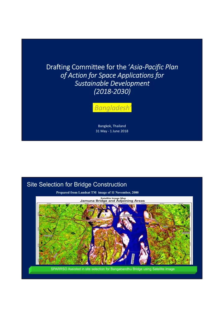

Drafting Committee for the ‘ Asia‐Pacific Plan of Action for Space Applications for Sustainable Development (2018‐2030) ‘Bangladesh’ Bangkok, Thailand 31 May ‐ 1 June 2018 Site Selection for Bridge Construction Prepared from Landsat TM image of 11 November, 2000 SPARRSO Assisted in site selection for Bangabandhu Bridge using Satellite image
Boro Coverage/ Area Estimation - 2016 (Routine activity for food security) Boro Coverage Map 2016 Example of Production Year Boro (lac % ha) 2005-06 44.13 30.02 2006-07 42.60 28.98 2007-08 46.30 31.49 2008-09 47.10 32.04 2009-10 47.80 32.52 Information is provided to the relevant ministries (Agriculture, Food, Relief & Rehabilitation) and SPARRSO website Satellite Based Observation of Crop Coverage March 28, 1975 March 28, 2015 Seasonal crops Mostly Bare land Bogra district 4
Advantage of Early Warning System: Satellite Advantage of Early Warning System: Satellite Monitoring and Tracking of Cyclones Monitoring and Tracking of Cyclones 12 Nov, 1970 Maximum wind Devastating speed: 223 km cyclone of 1970 Height of strom Year 2007 Year 1991 surge: 20-30 feet Year 1970 Death: 5,00,000 S 25 u rg 23 e in 29 April, 1991 19 ft. Maximum wind Devastating speed: 225 km W in 223 Height of strom d cyclone of 1991 s k 225 surge: 20-25 feet m p e e 250 Death: 1,38,000 d in D T e 500 h a o th u 138 to s 15 Nov, 2007 a o n 3.5 ls d Maximum wind s in Devastating speed: 250 km 0 2 0 0 4 0 0 6 0 0 Height of strom cyclone of 2007 surge: 15-20 feet Death: 3,500 Cold Wave & Persistent Fog Monitoring 12 JAN 10 16 JAN 10 07 JAN 07 10 JAN 10
Map of major Flood affected area (July‐August, 2016) 7 Flood Monitoring NOAA‐ Sept . 1988 NOAA- July 2004 NOAA- Aug. 2007 RADARSAT- Sept 1998 Flood affected area= 39.58% (2004) Flood affected area= 42.21% (2007) Reports Supplied to the Prime Minister Office, Ministry of Disaster Management & Relief and different Government offices Publish on the website for the public
Monitoring of Coastal Afforestation Mangrove afforestation along the coast of Bangladesh was started in 1960‐61 There was a comprehensive coastal mangrove afforestation program of the First (1980‐85) and second (1985‐ 90) Forestry Project The coverage of coastal plantation is 0.042 million ha in 2010 estimated from Landsat image interpretation Changes in coastal plantation (1989 - 2010) Patharghata 1989 2000 2010
Coastal Erosion and Forest Loss (1973‐2010) Sundarbans covering both Bangladesh and India Red: Forest loss Light green: Forest expansion Ash: Stable forest Orange: Stable other land Country Needs based on Priority Themes and Targeted Actions • Research and knowledge sharing: ‐ E.g. [What type of information, data and platform do you require to promote the use of space applications for the implementation of the SDGs?] ‐Exchange information from regional countries • Capacity building and technical support: ‐ E.g.[What type of training and technical support do you require? i.e. topic, frequency, level of training, tools, software, skills, etc.] ‐ Short and medium term training
Country Needs based on Priority Themes and Targeted Actions • Regional Norms and Standards: ‐ E.g. [What agreements do you think we need at the regional level to support the use of space applications for SDG implementation?] [What policies need to be strengthened?] [Which procedures or norms need to be defined further?] [What are the areas that can benefit from standardization?] ‐Policy on the better use of space technology in different sectors
Recommend
More recommend