Natural Hazards Return to Table of Contents Slide 5 / 142 What - PDF document
Slide 1 / 142 Slide 2 / 142 4th Grade Natural Hazards 2015-11-18 www.njctl.org Slide 3 / 142 Table of Contents Click on the topic to go to that section Natural Hazards Earthquakes Volcanoes Tsunamis Minimizing Damage Works
Slide 1 / 142 Slide 2 / 142 4th Grade Natural Hazards 2015-11-18 www.njctl.org Slide 3 / 142 Table of Contents Click on the topic to go to that section · Natural Hazards · Earthquakes Volcanoes · · Tsunamis Minimizing Damage · Works Cited ·
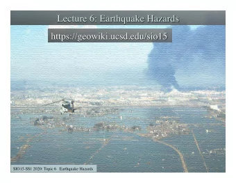
Slide 4 / 142 Natural Hazards Return to Table of Contents Slide 5 / 142 What happened? Look at the picture below. How many different ideas can you brainstorm about what may have destroyed this area? Source: Wikimedia Commons. Author: Abassi. Slide 6 / 142 What happened? This is the result of an earthquake that hit Haiti in 2010. Source: Wikimedia Commons. Author: Abassi. An earthquake is an example of a natural hazard. The next slides describe a different natural hazard that hit Alaska in the 1950s. Pay attention and see if you can come up with a definition for natural hazard.
Slide 7 / 142 Lituya Bay, Alaska Lituya Bay is a fjord located on the coast of Alaska. It is 14.5 km long and 3.2 km wide. A fjord is a narrow, deep inlet that runs between high cliffs. Source: Wikimedia Commons. Author: Nzeemin. Slide 8 / 142 Lituya Bay, Alaska Lituya Bay is part of the Glacier Bay National Park and Preserve.The Cascade Glacier, the Crillon Glacier and the Lituya Glacier all feed into Lituya Bay. Cenotaph Island is located in the middle of the bay. L i t u y a G r e l i a c a c l G i e e r d a c s a C Crillon Glacier Cenotaph Island Source: Chadron State College. Author: U.S. Geologic Survey. Slide 9 / 142 1953 - Lituya Bay In 1953, scientists visiting Lituya Bay found evidence of immense destruction around the bay. Click here to watch a video about the 1953 Lituya Bay event. Source: National Park Service After watching the video, move to the next slide to answer questions.
Slide 10 / 142 1953 - Lituya Bay What evidence of destruction did the scientists discover? Mature trees did not extend all the way down to the water, as it did in neighboring areas. Much younger trees were located by the water. What is a trim line? The place where trees of different ages meet. What information did the Juno Forestry Research Lab provide? The tree rings showed that a violent force struck the forest. Possibly a giant wave. Questions continue on next slide. Slide 11 / 142 1953 - Lituya Bay Why was this information confusing for the scientists? In order for a wave to reach that high in the forest, it would have had to be 150 meters tall. A wave this high had never been recorded before. It seemed impossible. The scientists were unable to make any sense of this information and they left the area puzzled. As a class, come up with a hypothesis about what happened. Write it below. Slide 12 / 142 1958 - Lituya Bay Five years later, a similar event happened. This time, however, the event was documented and had a few witnesses. Click here to listen to an eye witness acount of the event. Rockslide An earthquake caused a rockslide. Over 30 million cubic meters of rock fell into the bay from a height of 914 meters. The force of the rocks hitting the water created a mega tsunami that travelled through the bay. Source: Chadron State College. Author: U.S. Geologic Survey.
Slide 13 / 142 1958 - Lituya Bay This image shows the coastline of the bay. The lighter area is where the wave uprooted and destroyed all trees. The wave removed vegetation as high as 524 meters (1720 feet) above the waterline. It is the largest wave ever recorded. Source: Wikimedia Commons. Author: Miller. Slide 14 / 142 Natural Hazards What happened at Lituya Bay is an example of a natural hazard. A natural hazard is any extreme event that occurs from natural processes. Was there anything that could have been done to prevent the natural hazard in Lituya Bay in 1958? Write any ideas below. Slide 15 / 142 Natural Hazards Natural hazards cannot be prevented. However, by analyzing natural hazards, we can attempt to minimize the damage that they cause. Click here to watch a video of how scientists have analyzed the Lituya Bay mega tsunami. What did scientists learn about the wavelengths of mega tsunamis compared to storm waves? The wavelengths of mega tsunamis are incredibly large. This enables them to create a massive wave as it approaches shore and to engulf the land, causing immense destruction.
Slide 16 / 142 Natural Hazards In this unit, we will examine natural hazards that are a result of plate tectonics. Think back to the first unit of the year. What are plate tectonics and plate boundaries? Tectonic plates are pieces of the Earth's crust. Where tectonic plates come together and interact is called a plate boundary. Natural hazards from activity at plate boundaries include: Source: Wikimedia Commons. Author: McGimsey. Source: Wikimedia Commons. Author: Tubbi. Source: Wikimedia Commons. Author: Harriv. Volcanoes Earthquakes Tsunamis Slide 17 / 142 1 What initiated the destruction in Lituya Bay? A Hurricane B Rockslide C Earthquake D It is unknown. Slide 18 / 142 2 A natural hazard is any extreme event caused from natural processes. True False
Slide 19 / 142 3 Natural hazards can be prevented. True False Slide 20 / 142 Earthquakes Return to Table of Contents Slide 21 / 142 Plate Tectonics Remember that Earth's crust is composed of several different pieces that fit together like a puzzle. Source: Wikimedia Commons. Author: U.S. Geological Survey. The plates are constantly moving in relation to each other.
Slide 22 / 142 Faults There are areas in the Earth's crust where two plates rub against each other. These are called faults. In how many different ways can you imagine that plates rub against each other? Write your ideas below. Slide 23 / 142 Faults There are a few different ways that rocks can move in relation to each other. Two rocks can move horizontally beside each other (strike-slip fault). Click here to watch a strike-slip fault animation. A rock can be moved downwards (normal fault). Click here to watch a normal fault animation. A rock can be pushed upwards (thrust fault). Source: Wikimedia Commons. Click here to watch a thrust fault animation. Author: U.S. Geological Survey. Slide 24 / 142 Energy Review Think back to your unit on energy. Imagine that you compress this spring so that all the coils are touching each other. What will have more energy: the uncompressed spring or the compressed spring? Source: Wikimedia Commons. Author: Milan. What type of energy does the compressed spring have? If you suddenly let go of the spring, what type of energy does it have now?
Slide 25 / 142 Plates Can Store Energy Sometimes, the sides of plates are not completely smooth. They have bumps and irregularities that cause them to get stuck, or locked, in place when they should be moving past each other. Although the plates are no longer moving, the same amount of force is being applied to them. When plates stop moving, what type of energy is being stored at the fault? Potential energy This picture shows a strike slip fault in the Taklamakan Desert in China. Source: Wikimedia Commons. Author: NASA Earth Observatory. Slide 26 / 142 Plates Can Release Energy Eventually, there is so much force being applied to the plates that they become unstuck and quickly move past each other. The potential energy is suddenly released as what type of energy? Kinetic energy It is this sudden release of energy that is felt as an earthquake. This fault in France shows one side being pushed downwards while the other side moves upwards. Source: Wikimedia Commons. Author: Xhienne. Slide 27 / 142 4 Hold your hands together. Now, move them in a horizontal motion past one another. What type of fault are you simulating? A Strike-slip B Normal C Thrust
Slide 28 / 142 5 An earthquake is felt as plates gradually move past each other. True False Slide 29 / 142 Hypocenter The location within the Earth's crust where an earthquake originates is called the hypocenter. fault line hypocenter "hypo" means under Slide 30 / 142 Epicenter The location on the surface of the Earth directly above the hypocenter is called the epicenter. epicenter fault line hypocenter "epi" means above
Slide 31 / 142 Seismic Waves Energy is released during an earthquake as seismic waves. There are two types of seismic waves: S-waves and P-waves. Think back to your unit on waves. Transverse waves What type of waves travel up and down? Longitudinal waves What type of waves travel back and forth? This picture shows the aftermath of the 1906 San Francisco earthquake. Source: Wikimedia Commons. Author: National Archives. Slide 32 / 142 P-Waves P-waves are longitudinal waves that travel out from the hypocenter. P-waves are pressure waves. This means they compress rock. Hint: Think "P" for pressure or primary. Source: Wikimedia Commons. Author: Chan. P-waves travel quickly and are the first seismic waves to reach the epicenter (the location on Earth's surface above the hypocenter). These waves are felt as a sudden jolt. Slide 33 / 142 S-Waves S-waves are transverse waves that travel from the hypocenter of an earthquake. S-waves travel slowly through rock and are the second type of seismic wave to arrive at the epicenter. S-waves shear (distort) rock. Hint: Think "S" for shear or secondary. Source: Wikimedia Commons. Author: Chan. S-waves are felt as a prolonged side-to-side shaking. Click here to watch an earthquake animation that shows P-waves and S-waves.
Recommend


More recommend
Explore More Topics
Stay informed with curated content and fresh updates.