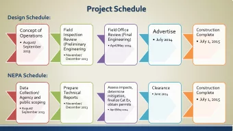
PUBLIC MEETING July 17, 2014 ESTIMATED PROJECT SCHEDULE Initial - PowerPoint PPT Presentation
PUBLIC MEETING July 17, 2014 ESTIMATED PROJECT SCHEDULE Initial Advisory Committee Mtg. July 18, 2013 Preliminary Alternates Spring 2014 Second Advisory Committee Mtg. June 12, 2014 Public Meeting July 17, 2014 Preferred Alternate
PUBLIC MEETING July 17, 2014
ESTIMATED PROJECT SCHEDULE Initial Advisory Committee Mtg. July 18, 2013 Preliminary Alternates Spring 2014 Second Advisory Committee Mtg. June 12, 2014 Public Meeting July 17, 2014 Preferred Alternate Selection Fall 2014
GEOMETRY Proposed design geometry will meet the criteria for a 35 mph design speed with smoother, flatter hills to provide a safer drive. Typical Sections
FUNDING Funding for this project is currently scheduled through KIPDA (Kentuckiana Regional Planning & Development Agency) as SLO funds which are Federal STP statewide funds dedicated to Louisville. KIPDA ID: 1879 Current Funding: $700,000 (Preliminary Design ) Right of Way, Utilities Relocation and Construction are currently not funded or scheduled. These phases could be added, including additional design, into the next few fiscal years once revised phase cost estimates are developed and the anticipated fiscal years are determined.
PURPOSE AND NEED Project Purpose Improve the access, safety and mobility of Beulah Church Road south of the Gene Snyder Freeway. Project Need The Beulah Church Road ( KY 864 ) corridor is a rapidly developing section of Louisville with increasing traffic demand. KY 864 is classified as an urban collector and has many access points. It carries traffic from growing residential suburbs to the Gene Snyder Freeway ( I-265 ) with growth expected to continue. Currently the Cooper Chapel Road extension ( 5-404.01 ) to Bardstown Road ( US 31E ) is currently under design and will bring additional traffic to the route.
TRAFFIC Segment 1 – Adams Run Road to Rocky Lane Segment 2 – Cedar Creek Road to Adams Run Road 2012 2032 ADT DHV ADT DHV Segment 1 7,600 960 9,600 1,210 Segment 2 5,300 660 6,700 820 ADT = Average daily traffic DHV = Design hourly volume
PROJECT CONSTRAINTS Existing subdivisions and subdivision entrances Several subdivisions are present along the east side of the roadway. Existing Utilities Several utilities existing in the corridor primarily along the west side of the roadway.
PROJECT CONSTRAINTS (continued) Cooper Chapel Road connection The proposed grades for the Beulah Church Road project must tie to the design that is underway for the extension project. Cedar Creek Road intersection improvements Correcting the poor sight distance at Cedar Creek Road is a project priority.
PROJECT CONSTRAINTS (continued) Property and Development We want to minimize impacts to homes, businesses and land. Unfortunately, some properties must be affected to improve the road. Engineering Design Guidelines Appropriate design standards are necessary for a safe and efficient road.
PUBLIC INVOLVEMENT Advisory Committee: A committee of representative stakeholders for the project was established that includes residents, home owner’s associations, school system, law enforcement and elected officials. The first meeting was held July 18, 2013, the second on June 12, 2014 The first Advisory Meeting was held July 18, 2013; the second on June 12, 2014. Three ( 3 ) utility coordination meetings have been held. The meeting tonight is the Public Information Meeting.
UTILITY COORDINATION Three Utility Coordination Meetings have been held. Utility owners in the area include: Louisville Water Company Louisville Gas and Electric Louisville Metropolitan Sewer District AT&T Time Warner Cable The Typical Section has been coordinated and adjusted to best accommodate utility relocations.
ENVIRONMENTAL This project is funded through Federal sources requiring the following to be investigated: Area Biology Historic and pre-historic resources Hazardous materials Impacts on humans (social, economic, air quality, noise) These investigations are underway, but considering the developed nature of the project area, their results are not expected to have a significant affect on the ultimate location of the proposed roadway.
DESIGN Three design alternates have been developed . Alternate No. 1 (red) includes a spot improvement at Cedar Creek and follows the existing Beulah Church centerline from Cooper Chapel to I-265 . Alternate No. 2 (blue) includes a spot improvement at Cedar Creek and is shifted east of the existing centerline approximately 7 to 13 feet from Cooper Chapel to I-265 . Alternate No. 3 (purple) includes a cross country alignment from Cedar Creek to Cooper Chapel to eliminate the two right angle turns on KY 864 and ties to Alternate No. 2 just past Cooper Chapel .
DESIGN SUMMARY Alternate Alternate Alternate No. 1 No. 2 No. 3 Mainline Length 0.94 miles 0.94 miles 1.63 miles Parcels Affected 63 64 82 Right of Way Needed 2.29 Acres 3.29 Acres 3.29 Acres Potential Structures 0 0 9 Affected Commercial 0 0 0 Residential 0 0 4 Farm 0 0 0 Storage 0 0 5 Earthwork (cubic yards) 19,488 21,498 53,653 Stream Crossings 1 1 3 TOTAL CONSTRUCTION COST $3.7 million $4.1 million $6.1 million
END Please ask any KYTC or GRW representative if you have any questions or comments. Your input is very important to the project and will be considered. Thank you for coming and please fill out and return the Comment Form!
PROJECT TEAM Kentucky Transportation GRW Engineers, Inc. Cabinet Design Consultant Keith Downs Tim Robinson Project Manager Project Manager Department of Highways Civil Division District 5 9710 Bunsen Parkway 8310 Westport Road Louisville, KY 40299 Louisville, KY 40242
Recommend


More recommend
Explore More Topics
Stay informed with curated content and fresh updates.