Gunica Bay/Rio Loco Agenda to Neutralize Detrimental Inputs (GRAND) - PowerPoint PPT Presentation
Gunica Bay/Rio Loco Agenda to Neutralize Detrimental Inputs (GRAND) By: Justin Leary, Rebecca Schurr, Polly Ni, and Luke Stirparo History and Background Founded on August 12, 1508, by Juan Ponce de Len Named Gunica, a word derived
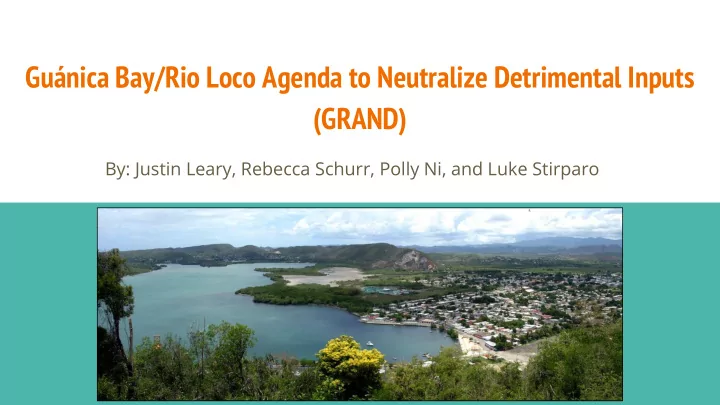
Guánica Bay/Rio Loco Agenda to Neutralize Detrimental Inputs (GRAND) By: Justin Leary, Rebecca Schurr, Polly Ni, and Luke Stirparo
History and Background Founded on August 12, 1508, by Juan Ponce de León ● Named Guánica, a word derived from the Taíno indigenous culture ● Means “here is a place with water” ○ Was a part of the municipality of Yauco ● until 1914 when it became separate Watershed includes urbanized areas of ● Yauco, a portion of the Lajas Valley agricultural region, and the upper watershed where coffee farming and subsistence agriculture is practiced
History and Background (cont.) Human alterations to increase drainage area included: ● Series of inter basin or inter-watershed water transfers ○ Five reservoirs ○ Two hydroelectric plants (Yauco 1 and 2) ○ High levels of deforestation due to sugarcane cultivation ● Ditching and draining of Guánica Lagoon, a large historical lagoon and ● adjacent wetland system, in the 1950s in addition to farmland clearing
History and Background (cont.) First watershed management plan created in 2008 ● Guánica Bay Watershed Management Plan ○ National Atmospheric and Oceanic Administration (NOAA) ○ The Puerto Rico Department of Natural and Environmental ○ Resources NOAA Coral Reef Management Fellow in Puerto Rico ○ In partnership with the Center for Watershed Protection ○ Plan was updated in 2014 ● Protectores de Cuencas and their partners ○ Done to address the EPA’s nine elements of ○ a watershed management plan
Mission Statement GRAND’s mission is to attain the classification of fishable water quality standards by the EPA in the Guánica Bay/Rio Loco Watershed in the Southwestern corner of Puerto Rico by the year 2040.
Problem 1: Coral Degradation Issue: Coral degradation is an arising ● issue throughout the world, Guánica Bay is no exception. Solution: Build basins/wetlands to contain the nutrients ● Introduce new agricultural methods such as hydroseeding ● Implement more farms to practice shade grown coffee ●
Problem 2: High Nitrate Levels Issue: Hurricanes Irma and Maria amplified nitrate effluent. ● Sources of nitrates include fertilizers from local farms and waste from residential ● areas. Excess nitrate encourages algal blooms which cause low dissolved oxygen levels, ● killing aquatic wildlife. Solution: Surround waterways and sources of nitrate with aquatic buffers: ● Man-made wetlands ○ Shade grown coffee ○
Problem 3: Erosion and Sediment Transport Issue: The Rio Loco has severe erosion problems ● Abandoned infrastructure and lack of mature ● trees in riparian zone cause instability of river banks Sediments are running into the river from ● exposed soils and dirt roads throughout agricultural areas Loss of reservoir capacity due to sediment build ● up Sediments traveling into the Guánica Bay are ● harming corals
Solutions for Erosion and Sediment Transport Solution: Bank Stabilization project including removing old infrastructure and planting ● native trees Sediment transport reduction by stabilizing dirt roads and using hydro ● seeding techniques to protect bare soils.
GRAND Goals Build basins/wetlands to contain the nutrients ● Introduce new agricultural methods such as hydroseeding to limit ● sediment run off. Currently, 20 acres of land was stabilized. By 2040, Grand proposes to stabilize more than ○ 150 acres of land. Implement more farms to practice shade grown coffee ● Ensure nitrate-nitrogen levels are 10 ppm or below. ● Carry out bank stabilization projects along the Rio Loco ●
Recommend

More recommend
Explore More Topics
Stay informed with curated content and fresh updates.