during Tropical Cyclones in the NCEP Hybrid Gridpoint Statistical - PowerPoint PPT Presentation
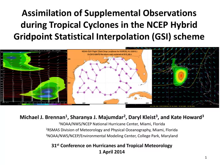
Assimilation of Supplemental Observations during Tropical Cyclones in the NCEP Hybrid Gridpoint Statistical Interpolation (GSI) scheme Michael J. Brennan 1 , Sharanya J. Majumdar 2 , Daryl Kleist 3 , and Kate Howard 3 1 NOAA/NWS/NCEP National
Assimilation of Supplemental Observations during Tropical Cyclones in the NCEP Hybrid Gridpoint Statistical Interpolation (GSI) scheme Michael J. Brennan 1 , Sharanya J. Majumdar 2 , Daryl Kleist 3 , and Kate Howard 3 1 NOAA/NWS/NCEP National Hurricane Center, Miami, Florida 2 RSMAS Division of Meteorology and Physical Oceanography, Miami, Florida 3 NOAA/NWS/NCEP/Environmental Modeling Center, College Park, Maryland 31 st Conference on Hurricanes and Tropical Meteorology 1 April 2014 1
Motivation • Previous studies (e.g., Aberson 2010; Majumdar et al. 2013) have examined the impact of synoptic surveillance dropsonde data on GFS model forecasts of TC track • In 2012 the NCEP Gridpoint Statistical Interpolation (GSI) data assimilation scheme was upgraded to use a hybrid ensemble-variational approach with characteristics of 3D-Var and an Ensemble Kalman Filter (Wang et al. 2013) • What is the impact of these supplemental observations in the new hybrid GSI on TC intensity and structure? 2
Karen (2013) • Karen formed as a 45-kt tropical storm early on 3 October 2013 in the Gulf of Mexico and reached a peak intensity of 55 kt later that day despite moderate vertical shear • As the shear increased Karen steadily weakened before dissipating on 6 October • Operational TC intensity guidance and global models showed Karen strengthening before reaching the northern Gulf Coast • Hurricane Watch was issued from Grand Kimberlain (2013) Isle, Louisiana, to Indian Pass, Florida GOES-E IR 3-6 October 2013 3
Karen Synoptic Evolution GFS Analysis 200-400 mb PV, 900-700 mb PV, 500-mb heights, and 200-400 mb layer average winds (kt) 4
Karen G-IV Mission • TROPICAL STORM KAREN DISCUSSION NUMBER 7 After the completion of the G-IV NWS NATIONAL HURRICANE CENTER MIAMI FL AL122013 mission, it was recognized 400 PM CDT FRI OCT 04 2013 operationally that the 12Z GFS THE GLOBAL MODELS ARE NOW IN BETTER AGREEMENT ON THIS EVOLUTION...AND SHOW THE MID-LEVEL CIRCULATION run trended much weaker with WEAKENING OR DISSIPATING ENTIRELY IN THE NEXT DAY OR TWO. IN PARTICULAR THE GFS IS WEAKER WITH ITS FORECAST the cyclone OF KAREN AFTER DATA FROM THE NOAA GULFSTREAM-IV JET...WHICH SHOWED 200-MB WINDS WEST OF KAREN STRONGER THAN PREVIOUSLY ANALYZED...WERE INCORPORATED INTO THE 12Z ANALYSIS. AFTER 24 HOURS... KAREN COULD STRENGTHEN A LITTLE DUE TO AN INCREASE IN UPPER-LEVEL DIVERGENCE AHEAD OF A MID-LATITUDE TROUGH...BUT SIGNIFICANT STRENGTHENING IS NOT EXPECTED. AN ALTERNATIVE SCENARIO IS THAT KAREN COULD BECOME COMPLETELY DECOUPLED FROM THE DEEP CONVECTION AND WEAKEN. Can we quantify this impact? G-IV dropsonde 200-mb winds (kt) and 1145 UTC GOES-E IR image 5
Karen NOAA G-IV Synoptic Surveillance Mission 0530-1300 UTC 4 October 2013 Sondes 15 – 38 Assimilated for 12Z Sondes 1 – 14 Assimilated for 06Z 6
Experiment Methodology • Quantify the impact of these observations using data denial experiments • Experiments run cycling GFS with the GSI hybrid EnKF data assimilation – Include all data (Control) – Exclude G-IV dropsonde data (No Drop) • Compare evolution of the TC and environment • Run SHIPS statistical-dynamical TC intensity model (DeMaria et al. 2005) on output from Control and No Drop experiments • All results shown here are from the 12Z cycle on 4 October to account for the impact of all dropsondes 7
Low-Level Vortex and Shear F00 – 12Z 10/4/2013 Control No Drop Shear Difference (Control – No Drop) • 925-700 mb PV • 850-200 mb wind shear magnitude • 850-200 mb wind shear (kt) 8
Low-Level Vortex and Shear F00 – 12Z 10/4/2013 Control No Drop Central Pressure: 1009 mb Central Pressure: 1009 mb 925-700 mb PV (shaded), 850-200-mb vertical shear magnitude (kt), 850-200-mb vertical wind shear (kt) 9
Vortex Structure (Analysis – 12Z 4 October) Control PV (shaded), Potential Temperature, Wind (kt) Relative Humidity (shaded), PV, Wind (kt) • W-E cross section along 25.2°N from 97°W to 83°W • Control shows more tilt in Karen’s PV tower in the 12Z analysis • Control also shows stronger upper-level winds west of Karen and more dry air over the western part of Karen’s circulation relative to No Drop 10
Vortex Structure (Analysis – 12Z 4 October) No Drop PV (shaded), Potential Temperature, Wind (kt) Relative Humidity (shaded), PV, Wind (kt) • W-E cross section along 25.2°N from 97°W to 83°W • Control shows more tilt in Karen’s PV tower in the 12Z analysis • Control also shows stronger upper-level winds west of Karen and more dry air over the western part of Karen’s circulation relative to No Drop 11
Drop 25 – 25.5°N 92.4°W 10Z 4 October G-IV Drop 10 UTC 12 UTC Analysis: GFS Control, GFS No Drop 12
Analyzed Profiles 1° W of Karen’s Center (25.2°N 90.9°W) 12 UTC Analysis: GFS Control, GFS No Drop 13
Low-Level Vortex and Shear F06 – 18Z 10/4/2013 Control No Drop Central Pressure: 1009 mb Central Pressure: 1008 mb GFS Intensity: 39 kt GFS Intensity: 43 kt 14
Low-Level Vortex and Shear F12 – 00Z 10/5/2013 Control No Drop Central Pressure: 1008 mb Central Pressure: 1007 mb GFS Intensity: 41 kt GFS Intensity: 42 kt 15
Low-Level Vortex and Shear F18 – 06Z 10/5/2013 Control No Drop Central Pressure: 1009 mb Central Pressure: 1009 mb GFS Intensity: 38 kt GFS Intensity: 36 kt 16
Low-Level Vortex and Shear F24 – 12Z 10/5/2013 Control No Drop Central Pressure: 1009 mb Central Pressure: 1008 mb GFS Intensity: 32 kt GFS Intensity: 32 kt 17
Low-Level Vortex and Shear F30 – 18Z 10/5/2013 Control No Drop Central Pressure: 1009 mb Central Pressure: 1009 mb GFS Intensity: 28 kt GFS Intensity: 35 kt 18
Low-Level Vortex and Shear F36 – 00Z 10/6/2013 Control No Drop Central Pressure: 1007 mb Central Pressure: 1006 mb GFS Intensity: 27 kt GFS Intensity: 41 kt 19
Low-Level Vortex and Shear F42 – 06Z 10/6/2013 Control No Drop Central Pressure: 1008 mb Central Pressure: 1005 mb GFS Intensity: 28 kt GFS Intensity: 40 kt 20
Low-Level Vortex and Shear F48 – 12Z 10/6/2013 Control No Drop Central Pressure: 1007 mb Central Pressure: 1004 mb GFS Intensity: 26 kt GFS Intensity: 38 kt 21
Low-Level Vortex and Shear F54 – 18Z 10/6/2013 Control No Drop Central Pressure: 1007 mb Central Pressure: 1003 mb GFS Intensity: 28 kt GFS Intensity: 42 kt 22
Low-Level Vortex and Shear F60 – 00Z 10/7/2013 Control No Drop Central Pressure: 1006 mb Central Pressure: 1003 mb GFS Intensity: 27 kt GFS Intensity: 48 kt 23
Vortex Structure (F60) Control PV (shaded), Potential Temperature, Wind (kt) Relative Humidity (shaded), PV, Wind (kt) • NW-SE cross section along from 33.8°N 92.4°W to 24.7°N 83.4°W • By F60, Control has weak vortex with dry air above that does not intensify ahead of approaching upper-level trough • Cyclone in No Drop is much deeper and appears to intensify in region of upper-level divergence 24
Vortex Structure (F60) No Drop PV (shaded), Potential Temperature, Wind (kt) Relative Humidity (shaded), PV, Wind (kt) • NW-SE cross section along from 34.5°N 91.2°W to 25.6°N 81.2°W • By F60, Control shows weak vortex with dry air above that does not intensify ahead of approaching upper-level trough • Cyclone in No Drop is much deeper and appears to intensify in region of upper-level divergence 25
Karen Intensity – GFS Experiments 26
SHIPS Model Experiments • SHIPS run off Control shows a weaker cyclone after 24 h, but only by 3-4 kt • Difference in intensity mainly due to weaker representation of the cyclone in GFS fields in Control relative to No Drop • SHIPS shear calculation was quite similar in both runs (SHIPS a 0 – 500 km area average with the TC vortex removed to compute shear) 27
Karen Track – GFS Experiments 12Z 10/4/2013 – Control, No Drop, Best Track 28
Summary • G-IV data appear to result in slightly stronger shear and more dry air aloft impinging on the circulation of Karen in the initial conditions at 12Z 4 October • No Drop experiment shows 10-15 kt strengthening in 24- 48 hours vortex as it approaches the northern Gulf Coast, perhaps through trough interaction • Control experiment shows gradual decay after 12 hours, qualitatively similar to observations • SHIPS experiments only show small differences, with SHIPS run from No Drop only 3-4 kt stronger than Control from 48-72 hours • These results suggest that G-IV dropsonde data may be useful in improving forecasts of structure and intensity in some cases 29
Future Work • Examine additional cases (Isaac 2012, 2014?) • See if any of the changes correlate with information in the EnKF-based ensemble • Examine impacts of individual observations or groups of observations to see if symmetrical flight track of G-IV could be modified 30
Acknowledgements • Thanks for Andrea Schumacher (CSU/CIRA) and Mark DeMaria (NHC) for running the SHIPS model experiments 31
Recommend
More recommend
Explore More Topics
Stay informed with curated content and fresh updates.
