Using remote sensing and geospatial techniques in hydrological - PowerPoint PPT Presentation
Using remote sensing and geospatial techniques in hydrological applications Nishan Bhattarai and Lindi J. Quackenbush Environmental Resources Engineering SUNY College of Environmental Science and Forestry Syracuse, NY Water Balance Equation P
Using remote sensing and geospatial techniques in hydrological applications Nishan Bhattarai and Lindi J. Quackenbush Environmental Resources Engineering SUNY College of Environmental Science and Forestry Syracuse, NY
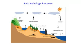
Water Balance Equation P = ET + Q (Runoff) + Δ S (change in storage) Transpiration Precipitation (P) Evapotranspiration (ET) Evaporation Water yield (WY), Runoff (Q) Subsurface inflow Groundwater recharge
Objective and Study Area Main objective Use remote sensing and geospatial techniques to estimate runoff at a watershed level
Methods 2008 Landsat (8) and MODIS (33) Precipitation from NOAA stations images 1. Landsat-only ET model 2. MOD16 ET products (Mu et al. 2007,2011) Remote Spatial 3. Landsat-MODIS ET fusion model -Utilizes surface energy balance Sensing of ET interpolation equations, linear regression models, and fuses MODIS and Landsat images 2008 Seasonal 2008 Annual P-ET and Annual ET Precipitation (P) 2008 Annual runoff (Q) or water yield (WY) Runoff Coefficients (Runoff/Precipitation)
Results- ET and runoff 2008 annual precipitation; and estimated ET and runoff using Landsat-MODIS ET fusion model
Results-runoff coefficients
Annual Discharge in cubic feet per second (cfs) at the USGS station 140 RE = 28% 120 RE = 9% Discharge (cfs) 100 80 RE* = 47% 60 40 20 0 Measured Landsat-only ET MOD16 ET data Landsat-MODIS ET fusion model model RE* = Relative Error (100* |measured-estimated|/measured)
Conclusions • Our Landsat-MODIS ET fusion model was found to be useful in predicting watershed annual ET and runoff with good accuracies. • Future study will study changes in surface runoff under different Land use and land cover change scenarios. • Future study will also cover other years and watersheds.
Recommend


More recommend
Explore More Topics
Stay informed with curated content and fresh updates.