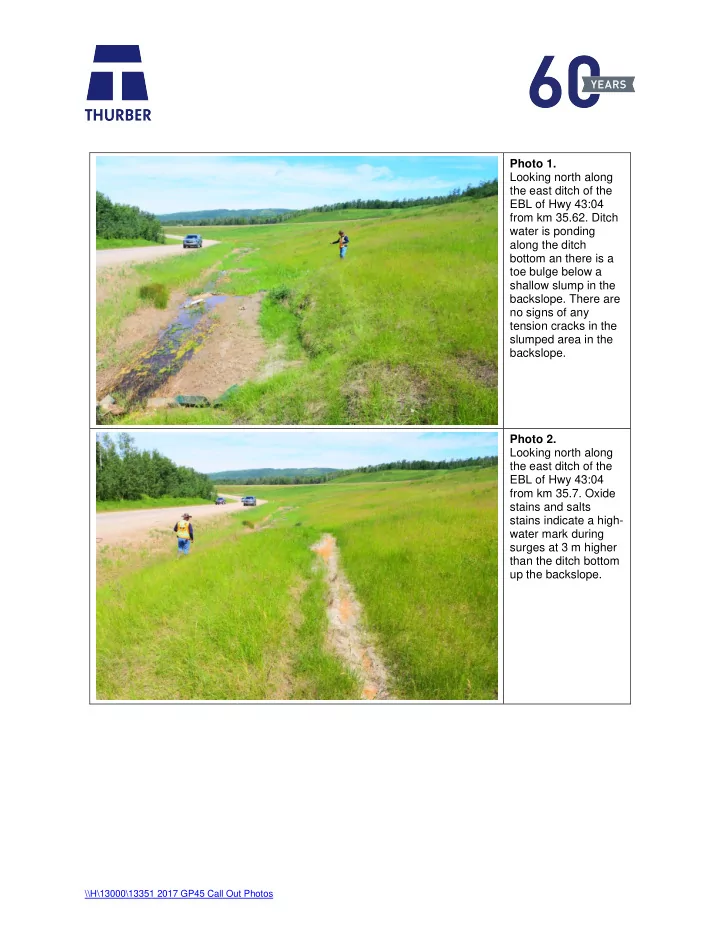

Photo 1. Looking north along the east ditch of the EBL of Hwy 43:04 from km 35.62. Ditch water is ponding along the ditch bottom an there is a toe bulge below a shallow slump in the backslope. There are no signs of any tension cracks in the slumped area in the backslope. Photo 2. Looking north along the east ditch of the EBL of Hwy 43:04 from km 35.7. Oxide stains and salts stains indicate a high- water mark during surges at 3 m higher than the ditch bottom up the backslope. \\H\13000\13351 2017 GP45 Call Out Photos
Photo 3. Looking south along the east ditch of the EBL of Hwy 43:04 from km 35.7. The toe roll of the landslide in the median backslope above the ditch is partially obstructing water flow. Photo 4. Looking east from the west sideslope on the EBL of Hwy 43:04 at km 35.7 at the landslide in the median backslope. The landslide is 75 m in width and extends 55 m from the west side ditch of the EBL up the backslope. \\H\13000\13351 2017 GP45 Call Out Photos
Photo 5. Looking south along the east ditch of the EBL of Hwy 43:04 from km 35.64. The toe roll of the landslide in the median backslope is partially obstructing water flow in the ditch. Sediment is also accumulating downstream of the toe roll debris as it is being eroded by the ditch water flow. Photo 6. Looking east along the toe at the north flank of the landslide in the median backslope above the EBL of Hwy 43:04 at km 35.78. \\H\13000\13351 2017 GP45 Call Out Photos
Photo 7. Looking southeast along the north flank of the backscarp of the landslide in the median backslope above the EBL of Hwy 43:04 at km 35.78. The average drop in the backscarp is 1 m at this location. Photo 8. Looking southeast along the backscarp of the landslide in the median backslope above the EBL of Hwy 43:04 at km 35.78. \\H\13000\13351 2017 GP45 Call Out Photos
Photo 9. Looking northwest along the backscarp of the landslide in the median backslope above the EBL of Hwy 43:04 at km 35.78. The drop along the backscarp varies between 0.5 m to 1.2 m and the larger tensions cracks are open to 0.5 m. Photo 10. Looking northeast along the backscarp of the landslide in the median backslope above the EBL of Hwy 43:04 at km 35.78. Tension cracks and small grabens are developing along the backscarp. \\H\13000\13351 2017 GP45 Call Out Photos
Photo 11. Looking southwest along the backscarp of the landslide. The drop along the backscarp varies from 1 m to 2.3 m. Photo 12. Looking west along the south flank of the backscarp of the landslide in the median backslope of Hwy 43:04 above the EBL at km 35.78. Tension cracks are developing upslope of the landslide backscarp. \\H\13000\13351 2017 GP45 Call Out Photos
Photo 13. Looking southwest from the mid-slope height of the median towards the sinkhole that has developed above the EBL east side ditch of Hwy 43:04 at km 35.6. Photo 14. Looking east from the upslope side of the sinkhole above the EBL of Hwy 43:04 at km 35.6. The sink hole is 18 wide and extends from the toe of the median backslope ditch 18 m up the backslope. \\H\13000\13351 2017 GP45 Call Out Photos
Photo 15. Looking northeast from east ditch of the EBL of Hwy 43:04 at km 35.6 at the sinkhole in the median backslope. Photo 16. Looking northeast from the east ditch of the EBL of Hwy 43:04 at km 35.6. The height of the drop along the backscarp of the sink hole varies from 1.8 m to 2.3 m. the depth water accumulated in the sink hole is 1 m. \\H\13000\13351 2017 GP45 Call Out Photos
Photo 17. Looking west from the upslope side of the sinkhole above the EBL of Hwy 43:04 at km 35.6. Photo 18. Looking northwest from the west shoulder of the EBL of Hwy 43:04 at km 35.579. A shallow skin failure as developed on the north side of the outlet of the 900 mm dimeter SWSP. \\H\13000\13351 2017 GP45 Call Out Photos
Photo 19. Looking at outlet of the grouted 2000 mm CSP on the west sideslope of the EBL at km 35.759. Photo 20. Looking at outlet of the 900 mm SWSP on the west sideslope of the EBL at km 35.759. \\H\13000\13351 2017 GP45 Call Out Photos
Photo 21. Looking into the 900 mm SWSP from the outlet end at km 35.759 on the west sideslope of the EBL of Hwy 43:04. The pipe is frozen. Photo 22. Looking southwest along the east shoulder of the Hwy 43:04 WBL at alligator cracking and rutting in the ACP above the clogged inlet to the 1200 mm diameter CSP centerline culvert at km 36. \\H\13000\13351 2017 GP45 Call Out Photos
Photo 23. Looking south along the east shoulder of the Hwy 43:04 WBL at alligator cracking and rutting in the ACP above the clogged inlet to the 1200 mm diameter CSP centerline culvert at km 36. Photo 24. Looking southeast from the west shoulder of Hwy 43:04 across the WBL near km 36 at alligator cracking, rutting in the ACP and dip in the guardrail above the clogged inlet to the 1200 mm diameter CSP. \\H\13000\13351 2017 GP45 Call Out Photos
Photo 25. Looking west from the east shoulder of Hwy 43:04 across the WBL near km 35.8 at alligator cracking and rutting in the ACP. Photo 26. Looking at clogged inlet to 1200 mm diameter CSP east of WBL at km 35.8. \\H\13000\13351 2017 GP45 Call Out Photos
Recommend
More recommend