On Friday, July 6, 2012 George Garcia and Gene Tomlinson provided - PDF document
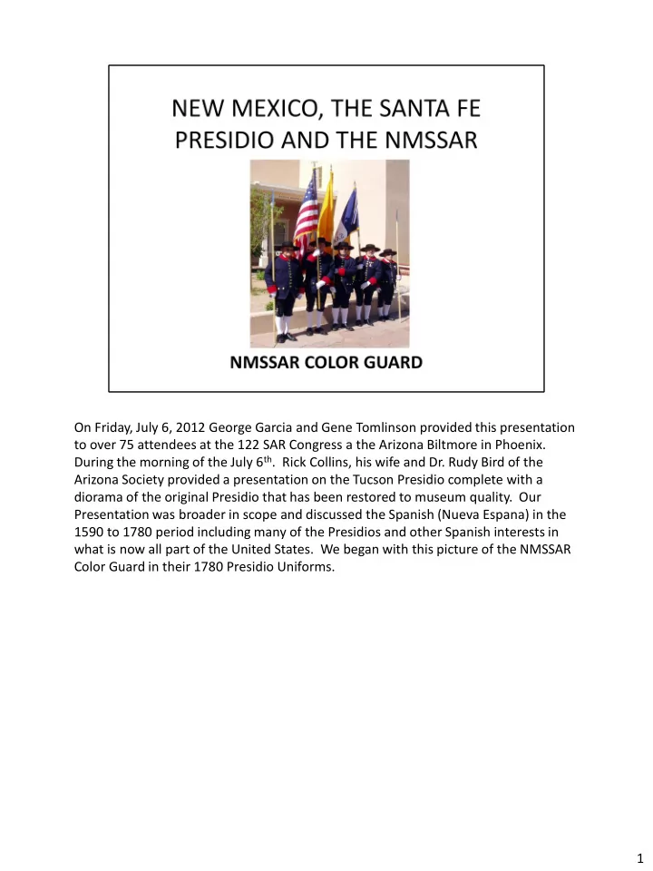
On Friday, July 6, 2012 George Garcia and Gene Tomlinson provided this presentation to over 75 attendees at the 122 SAR Congress a the Arizona Biltmore in Phoenix. During the morning of the July 6 th . Rick Collins, his wife and Dr. Rudy Bird of
On Friday, July 6, 2012 George Garcia and Gene Tomlinson provided this presentation to over 75 attendees at the 122 SAR Congress a the Arizona Biltmore in Phoenix. During the morning of the July 6 th . Rick Collins, his wife and Dr. Rudy Bird of the Arizona Society provided a presentation on the Tucson Presidio complete with a diorama of the original Presidio that has been restored to museum quality. Our Presentation was broader in scope and discussed the Spanish (Nueva Espana) in the 1590 to 1780 period including many of the Presidios and other Spanish interests in what is now all part of the United States. We began with this picture of the NMSSAR Color Guard in their 1780 Presidio Uniforms. 1
To give the attendees an overview of New Mexico we used this map of the state to show the location of Santa Fe the State’s Capitol and how it is connected to Albuquerque and Las Cruces. The map also shows the major interstate routes through the State. 2
A comparison of the two sponsoring States for the 122 Congress each entering the union 100 years ago is interesting to review. New Mexico follows Alaska, Texas, California and Montana in size, but has less population that many smaller states and only one third the population of Arizona. Though the mean altitude of New Mexico is half that of Arizona, both Albuquerque at over 5000 feet and Santa Fe just over 7.000 feet above sea level are considerably above Phoenix and Tucson. We can say that in Santa Fe we sleep, eat, and walk at an altitude where many folks jump out of an airplane to skydive. 3
Important when we look into our southwestern US history is to relate the geographic size of Spain and France to that of the States of Arizona and New Mexico. With over 20 times the population, they are infact not quite twice the size of either New Mexico or Arizona. 4
If we were to add our two states area together we are occupying more land that either France or Spain. We want to note that if we look at just a portion of Nuevo Espania as a land mass we can see that the holdings of France and Spain in the “New World” were more than half again the size of their two countries. No European monarch or their leadership could comprehend the vastness of the Southwestern part of North America and hence had little idea of what they really had explored and were attempting to manage in the 1700’s. 5
Though the map of New Mexico and for that matter most of the adjoining states changed continually in the mid to late 1800’s with the westward expansion and the coming of the railroads and discovery of gold, this map depicted the Territory in 1857, 55 years before it was divided into the States of New Mexico and Arizona. 6
To illustrate the problem Europeans still have with the size of the U.S. a true story about a French engineer with Renault can give a good indication of the thought process. John Ives wanted to take his family on a four day trip around the US going from Detroit to Boston, New York City, Washington, Cape Canaveral, New Orleans, Hollywood, San Francisco, and St. Louis and back to Detroit bringing on Wed. evening and returning on the following Monday Evening. I told him- ”not possible even if he had a potty in the car”. Oh, he said, “too far!” and I said, “yes, John way to far”. This was in 1983, can we even imagine what the King of France or Spain would be able to grasp in the 1700’s. They would think it was a long trip just to go from Paris to Madrid. 7
So to sum it up, New Mexico, the 47 th State and 5 th largest has a population of just over 2 million – about half Hispanic (many preferring to speak only Spanish) and half of everybody else. The state recognized from the beginning that Spanish was the second language and it provided for it in its constitution. Other than Hawaii, it is the only state that is constitutionally bi-lingual. 8
New Mexico is the place of maxitli the Aztec God. Now the Land of Enchantment it has several interesting features that distinguish it from all others states. 9
So for all of you history “buffs” here is a one page summary of the History of New Mexico. If you visit Santa Fe you will be walking on the same ground in downtown that was the Presidio of Santa Fe in 1780. The roads of old and the streets of today are essentially the same. Some of the buildings in the city date back to the early 1600’s. Yes, even before Jamestown. Santa Fe is the oldest capitol in the United States and Spanish is heard as much as English when you visit Santa Fe. 10
As the Spanish established outposts and settlements in the 1600’s and 1700’s in Nuevo Mexico they built presidios or forts. Except in Santa Fe where there was all the workings of a presidio, but it was not a walled enclave. 11
Spain built and occupied presidios from Florida the San Francisco. They even had outposts in the State of Washington to stop the Russians from occupying that area. (The Straits of Juan de Fuego are not named for the English or the French, but for a Spaniard). Several of the Presidio’s, like Tucson are still maintained and can be visited. If you are in Florida, go to the fort in Saint Augustine. When you visit Santa Fe, stand in the middle of the Plaza and you can imagine the troops working and parading on that very ground. 12
This map shows the location of many of the presidios that the Spanish built across all of North America. 13
Presidio La Bahia in Texas was a typical presidio. So was the Alamo in San Antonio. 14
Typical of the presidios is Presidio de Tubac shown here in a 1755 drawing. 15
The Presidio Santa Barbara (show in 1785) was a major stopping point along the west coast and provided shelter and protection to the Spanish and their native allies who converted to Christianity and worked the fields around the presidio. 16
Perhaps difficult to read, this 1780 map of New Mexico shows the El Camino Real coming up from Mexico City and going all the way up to Santa Fe and beyond. The Spanish had good map makers who documented much of the southwest as well as Florida across to and including Texas. 17
The first paragraph of this slide is the translated instructions to Don Pedro de Peralta to build a presidio and six districts (living and farming areas) around Santa Fe. The settlement of Santa Fe probably began at least two years earlier, but is not well documented. Since there were no walls or fortifications around the Presidio in Santa Fe, the Pueblo Indian uprising in 1680, drove most of the Spanish back to the Rio Grande at Juarez (El Paso). They returned in force and in mass in 1690 to retake Santa Fe . You can walk through the Museum at the Palace of the Governors on the Plaza and see the building the way it was then and is now. Territorial Governor, Lew Wallace, completed the last two chapters of his book Ben Hur while sitting in the corner office of the Palace. That space is now the Palace office and you can look up your Spanish Soldier ancestor who served and supported our Revolution with his two peso’s. We have the listing of all those who gave at the request of King Carlos III to add to his war chest and support with goods and arms for our Revolution. 18
This is the Palace of the Governors and a fine Museum. Our native American friends come daily and sell their goods under the portal. They can be seen sitting their in this picture. Up to 103 spots are available for them and lots are draws each morning to see who can have a place to present their work. Good jewelry and other items made by the person you will meet or by one of their family are available. 19
This is a good map of Santa Fe drawn around 1770 by Umutia. If you look closely you will see the location of the Palace of the Governors (Casa Real), the church of St Francis ( now the Cathedral), the Saint Miguel Chapel (still the Saint Miguel Chapel – oldest church in North America and still in operation), the living quarters for the troops, the Plaza and the soldier’s chapel (now a store – note the plaques on the entrance to the store when you visit and shop). The Santa Fe river is shown and still exists in the same location as on the map as well as the main roads – Camino Real (now Cerrillos), the road south, (St. Francis ) and the road southeast (now the Santa Fe Trail). The acequia is the Acequia Madre or Mother ditch, still brings water down from the mountains and runs year round next to the street of the same name. 20
Recently recoated to protect it, the San Miguel Chapel sets just a block and a half from the end of the Santa Fe Trail exactly where it was built in 1610. The Santa Fe Trail ends at the Plaza . 21
The Spanish declared war on England in early 1779. It did ,however, supply General Washington from early into the Revolution through its French connection and with the support of its forces under General Galvez on the Gulf coast of the United States. The purpose of the Spanish support was to retake land and islands in the Caribbean lost to the English in the was of 1773. The Spanish did retake most of all the land lost to the English and also explored up the Mississippi and even over Lake Michigan to the Benton Harbor, Michigan area. They moved cattle from Mexico to supply Galvez’s army and sent some of the cattle up the Mississippi to Vincennes, Indiana and overland to Valley Forge for Washington’s troops. 22
Recommend


More recommend
Explore More Topics
Stay informed with curated content and fresh updates.