
SLIDE 1
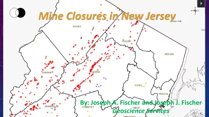
Mine Closures in New Jersey
By: Joseph A. Fischer and Joseph J. Fischer Geoscience Services
Mine Closures in New Jersey By: Joseph A. Fischer and Joseph J. - - PowerPoint PPT Presentation
Mine Closures in New Jersey By: Joseph A. Fischer and Joseph J. Fischer Geoscience Services Iron Valley and Ridge Physiographic Province Graphite Manganese Highlands Physiographic Province Copper Mica Piedmont Physiographic Whispering
By: Joseph A. Fischer and Joseph J. Fischer Geoscience Services
Iron Graphite Manganese Copper Mica Sulfide
Dickson Mine Whispering Woods Mine Cooper Mine Highlands Physiographic Province Valley and Ridge Physiographic Province Piedmont Physiographic Province
before the Civil War to the later 19th century.
Labor, Mine Safety Div. MCPs are submitted to the DoL by a licensed NJ Prof. Engineer.
existing mines and will freely disseminate the information.
considered high-grade ore at the time.
beds/veins of ore were followed downward, usually at an angle, forming a stope.
though not as extensively as iron.
the mid-1800’s.
processing mill.
prompted contact with developer.
location of a likely mine shaft in the front yard and one near a depression in the rear yard.
600 to 1,200 feet/sec and bedrock velocities in excess of 3,000 feet/sec.
bottom of the depression was at 102 to 103 feet below grade.
and monitored by the authors.
mining activity.
exploration for ore in the area.
possible without sending anyone down into the shaft.
excavation and pushed/pressed into small shaft extending from the side of the shaft.
for shrinkage) was introduced.
grade with granular fill and topped with 2 feet of topsoil.
the 1980’s. The developer got permission to develop the lot despite mine features as long as no structures nearby.
small stoped mine.
and accepted.
by homeowner.
stope with large boulders, then reduce material size to choke
dewatering with 2 large pumps for more than a week, excavation and timber cutting.
mine or to close the mine was revealed.
contractor, resulting from underestimating material costs causes cessation of work.
information provided by the NJGW&S.
Original assumed location Revised location
extend well beyond
a shaft to a deep, stoped mine.
choke with boulders.
possible, what next?
some mine infilling took place during abandonment and that
manageable quantities.
costs. As an aside, the Township official responsible for mines promised to help in our data search for the information on the Cooper Mine on the lot, and promptly resigned. No replacement for them as of this date.
bedrock.
the development.
question the original 1994 study as features shown on consultants plan for easterly lot (Lot 2) were not evident in the field.
Lot 2 Lot 3
Line” from the original study. Original “features” could not be accurately identified.
within the mapped stope area (north and west of “Exclusionary Line”) to confirm
nearby at the surface.
northerly property line.
graded in late 1990’s
done to date.
“Exclusionary Line”, including a deed restriction for swimming pools, etc., so purpose of MCP is to stop overburden materials from eroding into the stope and densify the materials that fill the shafts to prevent undo settlement. A safety not structural issue.
activity, but 1994 probes indicated that they are all likely a result of test pits searching for additional magnetite ore. Exception is a single shaft.
shaft.
“Exclusionary Line” and continuing north and west until it is determined where the stope daylighted.
voids.
encountered conditions.
grouting techniques to densify materials and fill voids.
test pits searching for additional magnetite ore. Exception is a single mine shaft to be grouted during Lot 2 work.
equipment during construction on Lot 2.
structural fill.
determined upon the basis of the encountered feature(s).