
Webinar Tit le Is Y our County Resilient to Flooding? A County - PowerPoint PPT Presentation
Webinar Date 1 Webinar Tit le Is Y our County Resilient to Flooding? A County Inundation Toolkit Webinar Dat e 2 3 How to Participate About the National Association of Counties advances issues before the federal government;
Webinar Date 1 Webinar Tit le
Is Y our County Resilient to Flooding? A County Inundation Toolkit Webinar Dat e 2
3 How to Participate
About the National Association of Counties • advances issues before the federal government; • improves understanding of county government; • assists counties in finding and sharing innovative solutions • provides value-added services to save counties money. For more informat ion visit NACo's new Websit e: www.naco.org. 4
Tips for viewing this webinar: • The questions box and buttons are on the right side of the webinar window. • This box can collapse so that you can better view the presentation. To unhide the box, click the arrows on the top left corner of the panel. • If you are having technical difficulties, please send us a message via the questions box on your right. Our organizer will reply to you privately and help resolve the issue. 5
Question & Answer S ession Instructions • Type your question into the questions box at any time during the presentation, and the moderator will read the question on your behalf during the Q&A session. 6
7 Partners
Moderator: Alyssum Pohl NOAA Digital Coast Fellow Alyssum has a background in marine conservation, and is delighted to be spending 2 years at NACo, helping counties implement GIS and other digital tools to help with their issues related to coastal resiliency. 8
Agenda: • How to identify risk and vulnerability • Tools to visualize inundation • Communicate with community about issues, concerns, and values 9
Darrin Punchard, AICP , CFM Conducting Risk and Vulnerability Assessments Angie Graj eda Communicating with Alyssum Pohl, MAIEP Y our Community Tools to Visualize Inundation 10
11 Inundation…
12
13
Conducting Risk and Vulnerability Assessments A Critical S tep to Improving Resilience to Flooding Darrin Punchard 14
Is My County Resilient to Flooding? • Where to begin… – Talk to local Floodplain Administrator – Review local Hazard Mit igat ion Plan – Review FEMA Flood Insurance S t udy (FIS ) and Flood Insurance Rat e Map (FIRM) 15
FEMA ’s Risk MAP Program (Mapping, Assessment, & Planning) The vision for Risk MAP is to deliver quality data that increases public awareness and leads to action that reduces risk to life and property. www.fema.gov/ risk-mapping-assessment-planning 16
17 Risk MAP Products (non-regulatory)
Identifying Risk “ Floods are act s of God, but flood losses are largely act s of man.” - Gilbert F . White 18
Key S teps in Conducting a Risk Assessment 1. Assess the Hazard: Type – riverine, coastal, flash, urban, etc. Location – specific flood hazard areas, including those outside of “ mapped” floodplains Extent – severity or magnitude, as measured in flood depth, velocity, speed of onset, etc. Frequency - gather information on previous occurrences, and on the probability of future events* Sources and causes – natural versus human-caused * Consider fut ure condit ions of nat ural and built environment s 19
Key S teps in Conducting a Risk Assessment 2. Assess the Problem: Identify community “ assets” potentially at risk – people, buildings, critical facilities, infrastructure, etc., as well as natural features Consider relationships and dependencies between assets, and with what drives t he communit y – social, economic, cultural, and environmental systems Analyze risks – identify vulnerable assets, and quantify exposure using best available data and methods (preferably t hrough GIS ) Prioritize risks - summarize overall vulnerability and prioritize specific assets or areas for hazard mitigation strategies, based on potential losses and other impacts 20
21 Risk Assessment Examples: Assess the Hazard
22 Risk Assessment Examples: Assess the Hazard
23 Risk Assessment Examples: Assess the Hazard
Risk Assessment Examples: Assess the Hazard S tatistics on Flood Insurance Claims : http:/ / bsa.nfipstat.fema.gov/ reports/ 1040.htm 24
Risk Assessment Examples: Assess the Hazard Consult with your S tate NFIP Coordinator and/ or S tate Hazard Mitigation Officer for detailed claims data, including information on “ repetitive loss properties” (bound by Federal Privacy Act rest rict ions) Review past damage assessment reports and online sources, such as NOAA ’s NCDC S t orm Event s Dat abase S olicit input from the public and targeted stakeholders through various methods as part of planning process 25
26 Risk Assessment Examples: Assess the Problem
Risk Assessment Examples: Assess the Problem Maximize the use of best available datasets, technology, and methods 27
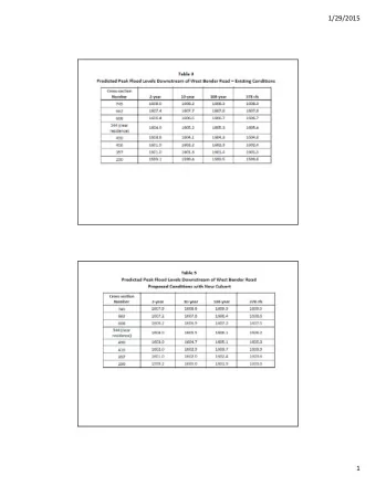
Risk Assessment Examples: Assess the Problem Buildings Located in Known Flood Hazard Zones Total Number of Assessed Total Number Total Number Assessed Developed Building Hazard Zone of Developed of Buildings Building Parcels (Pre- Value (Pre- Parcels Value (2007)* FIRM Only) FIRM Only)* Riverine Flood 1 Percent Annual Chance 5,098 4,557 $1,847,718,974 3,717 $1,738,743,974 0.2 Percent Annual Chance 3,135 3,253 $947,568,354 2,509 $856,511,354 Total 8,233 7,810 $2,795,287,328 6,226 $2,595,255,328 Coastal Flood Coastal VE Zone 75 76 $10,384,940 42 $5,068,940 Category 1 Storm Surge 233 236 $397,092,923 N/A N/A Category 2 Storm Surge 1,641 1,714 $668,141,943 N/A N/A Category 3 Storm Surge 12,735 11,674 $3,113,769,088 N/A N/A Category 4 Storm Surge 32,558 27,659 $7,304,470,145 N/A N/A Category 5 Storm Surge 38,272 31,923 $9,790,639,069 N/A N/A 28
Risk Assessment Examples: Assess the Problem Estimated Potential Losses to Flood Hazards Capital Stock Losses Business Interruption Losses Return Total Loss Total Total Capital Rental Interval Inventory Relocation Wage Building Contents Related Income Loss Loss Losses Damage Damage Loss Loss 10-Year $35,002,000 $44,332,000 $1,969,000 $226,000 $228,000 $1,148,000 $65,000 $82,970,000 50-Year $47,887,000 $60,430,000 $2,430,000 $316,000 $321,000 $1,255,000 $100,000 $112,739,000 100-Year $56,112,000 $73,797,000 $3,309,000 $390,000 $542,000 $1,501,000 $147,000 $135,798,000 500-Year $66,630,000 $88,974,000 $3,956,000 $445,000 $606,000 $1,861,000 $174,000 $162,646,000 Additional Impacts Caused by Flood Hazards Debris Generated Displaced Temporary Return Interval (tons) Households Shelter Needs 10-Year 10,821 2,407 5,124 50-Year 14,446 3,066 6,860 100-Year 15,368 3,164 7,194 500-Year 17,539 3,534 8,200 29
Risk Assessment Examples: Assess the Problem Table 4.5: Critical Facilities Located in Known Flood Hazard Zones Riverine Flood Coastal Flood 1 0.2 Facility Cat. 1 Cat. 2 Cat. 3 Cat. 4 Cat. 5 Percent Percent Coastal Storm Storm Storm Storm Storm Annual Annual VE Zone Surge Surge Surge Surge Surge Chance Chance Fire Stations ■ ■ Savannah Fire Department Station #1 ■ Savannah Fire Department Station #2 ■ ■ Savannah Fire Department Station #4 ■ ■ ■ Savannah Fire Department Station #6 ■ ■ ■ ■ Savannah Fire Department Station #7 ■ ■ Savannah Fire Department Station #8 ■ ■ ■ ■ Savannah Fire Department Station #10 ■ Savannah Fire Department Station #12 ■ SAV Airport Fire Department 30
Risk Assessment Examples: Assess the Problem Detached Garage Community Velocity Zone Encroachment Area Line Source of Parking Area Flooding 31
32 Risk Assessment Examples: Assess the Problem
Risk Assessment Examples: Assess the Problem Assessing S ea Level Rise Inundat ion in Coast al Connect icut Planning scenario = 1-meter increase by Y ear 2080 Mean High Water Inundation (no storm) 33
Digital Coast Tools for Inundation Visualization Alyssum Pohl 34
Global S ea Level Rise S cenarios for the United S tates National Climate Assessment http:/ / cpo.noaa.gov/ sites/ cpo/ Reports/ 2012/ NOAA_S LR_r3.pdf 35
36 Digital Coast
37 Coastal Inundation Toolkit
38 Coastal Inundation Toolkit
39 Understand
40 Coastal Inundation Toolkit
41 Coastal Inundation Toolkit
42 Visualize
43 napshots Coastal County S
44 napshots Coastal County S
45 Coastal Inundation Toolkit
46 Coastal Inundation Toolkit
S ea Level Rise and Coastal Flooding Impacts Viewer www.csc.noaa.gov/ slr 47
48
49
50
51
52
53
54
55
56
57
58
59
60
61 CanVis
Data Distribution Lots of Layers • Conditioned DEMs • SLR layers • Marsh migration layers • Uncertainty layers • Shallow coastal flooding layer • Social Vulnerability Index data • Bureau of Labor Statistics data 62
Data Distribution Lots of Ways to Distribute • Raster geodatabases via HTTP • Representational State Transfer (REST) page (map services) • Enabling mash ‐ up applications 63
Recommend


More recommend
Explore More Topics
Stay informed with curated content and fresh updates.