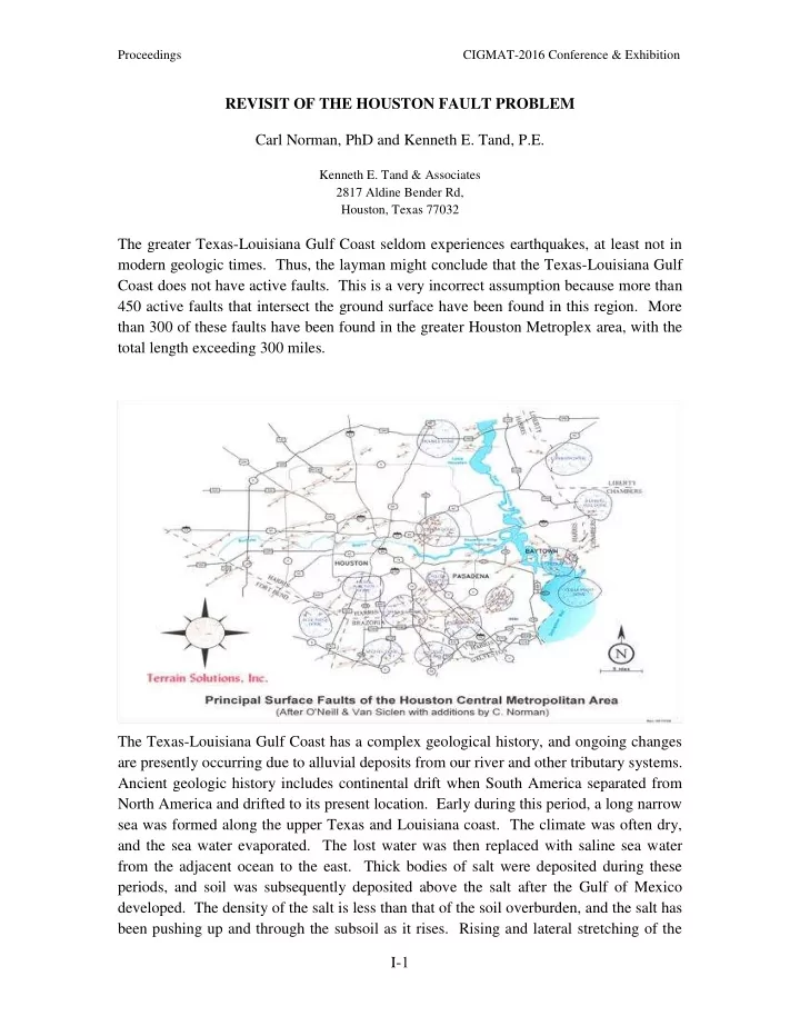

Proceedings CIGMAT-2016 Conference & Exhibition REVISIT OF THE HOUSTON FAULT PROBLEM Carl Norman, PhD and Kenneth E. Tand, P.E. Kenneth E. Tand & Associates 2817 Aldine Bender Rd, Houston, Texas 77032 The greater Texas-Louisiana Gulf Coast seldom experiences earthquakes, at least not in modern geologic times. Thus, the layman might conclude that the Texas-Louisiana Gulf Coast does not have active faults. This is a very incorrect assumption because more than 450 active faults that intersect the ground surface have been found in this region. More than 300 of these faults have been found in the greater Houston Metroplex area, with the total length exceeding 300 miles. The Texas-Louisiana Gulf Coast has a complex geological history, and ongoing changes are presently occurring due to alluvial deposits from our river and other tributary systems. Ancient geologic history includes continental drift when South America separated from North America and drifted to its present location. Early during this period, a long narrow sea was formed along the upper Texas and Louisiana coast. The climate was often dry, and the sea water evaporated. The lost water was then replaced with saline sea water from the adjacent ocean to the east. Thick bodies of salt were deposited during these periods, and soil was subsequently deposited above the salt after the Gulf of Mexico developed. The density of the salt is less than that of the soil overburden, and the salt has been pushing up and through the subsoil as it rises. Rising and lateral stretching of the I- 1
Proceedings CIGMAT-2016 Conference & Exhibition overburden causes shearing displacements (faults) that radiate outward from the salt intrusion. These features are termed “salt dome faults”, and th ey comprise about 80 percent of the faults. There is a longer and larger system of faults that are more or less parallel to the coast line. The primary faults are down to the coast, and complimentary faults formed parallel to the primary faults due to a complex stress field. The ground shearing is similar to what is observed in a massive landslide, but geologists have not used this analogy because the shearing surfaces do not terminate in empty space. There are often lateral offsets in the fault lines, and the faults become monoclines at their distal ends where strain rates become vanishingly small. The faults are non-linear shear fractures in the subsoils that extend to depths of hundreds to tens of thousands of feet below the ground surface. Near the surface the dips are generally in the order of 70 to 85 degrees from the horizontal. They are observed to become nearly horizontal at great depths. Of significance is that there are both vertical and horizontal components of surface ground movement. The faults have been intermittently active for hundreds of thousands to millions of years. Recently measured vertical movements have ranged from zero at the end of faults to slightly more than 1 inch per year for the most active faults (generally ½ ± ½ inch per year). Of special interest is that one or more new faults are presently being found each year. Some geologists and geotechnical engineers believe that the old faults became inactive until recent times when withdrawal of oil and groundwater reactivated them. Some geologists, such as Carl Norman, PhD., believe that the faults have always been intermittently active since their inception. The principal of effective stress tends to support Dr. Norman’s beliefs that excessive groundwater pumpage did not cause activation of the faults. Some of the early found faults located in areas of shallow prolific oil production, such as Spindletop, were probably the result of soil overburden that densified when the oil, water and soil were removed (deep differential settlement-induced surface fractures). The “jury” is still out on this subject. However, the important observation is that the faults are still active even though oil and groundwater pumpage has been reduced. Thousands of residential, commercial and industrial structures have been built unknowingly across faults. They require periodic repairs to retain their structural integrity, and sometimes have to be demolished and rebuilt elsewhere. Thus, it is advantageous to locate faults so that they can be avoided. Also, infrastructure such as roads, bridges and underground utilities cross the faults, and it is best to design them for maintenance. Typical means of locating faults are outlined below: I- 2
Proceedings CIGMAT-2016 Conference & Exhibition Review of published maps showing surface faults Review of deep petroleum maps showing deep subsurface faults Review of old and new USGS topographical maps showing ground contours Field reconnaissance to locate pavement breaks and field scarps, as well as distressed buildings, sidewalks, and roadways Close grid elevation surveys Review of black & white, and colored aerial photographs Aerial LIDAR Identification of offsets in the subsoil layers using electrical resistivity profiling in deep boreholes (expensive) High-resolution shallow seismic lines (uncommon and expensive) Surface resistivity profiling (not found to be reliable) Identifying and locating faults requires a high degree of training, and extensive experience. Recent graduate geotechnical engineers and geologists must be mentored extensively to develop the required skills. There are known instances where unskilled engineers and geologists have rendered incorrect conclusions regarding the existence and location of faults. I- 3
Recommend
More recommend