
Morphogenesis of Soils Associated with Frost Boils C.L. Ping 1 , - PowerPoint PPT Presentation
Morphogenesis of Soils Associated with Frost Boils C.L. Ping 1 , G.J. Michaelson 1 J. M. Kimble 2 , Y. L. Shur 3 , D. A. Walker 4 1. Palmer Research Center, SALRM, University of Alaska 2. USDA-NRCS National Soil Survey Center, Lincoln, NE 3.
Morphogenesis of Soils Associated with Frost Boils C.L. Ping 1 , G.J. Michaelson 1 J. M. Kimble 2 , Y. L. Shur 3 , D. A. Walker 4 1. Palmer Research Center, SALRM, University of Alaska 2. USDA-NRCS National Soil Survey Center, Lincoln, NE 3. Dept. Civil Engineering, University of Alaska Fairbanks 4. Dept. Biology, University of Alaska Fairbanks
INTRODUCTION Frost boil, or called mudboils, is a kind of nonsorted circles. It is self- organized pattern ground commonly occur in the Arctic regions (Washburn, 1982). The unique feature of the frost boil, like fresh mud boiled over the surrounding tundra, has long attracted interests among geocryologists, pedologists and geologists. Recently, the importance of biodiversity caused by the frost boil sequence has been recognized and a multidisciplinary team was organized to study the interactions of the frost boil dynamics, with vegetation, nutrient cycling and soil development (Walker et al., 2001). The objective of this project is to study the genesis of frost boils based on morphologic properties.
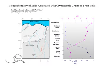
Figure 1. Locations of study sites, Arctic Alaska
MATERIALS AND METHODS A. Study Area The study area is at the Arctic Foothill in Northern Alaska (Figure 1) and the study sites are associated with the NSF-ARCSS Land-Atmosphere-Ice-Interaction (LAII) projects and the NSF Biocomplexity project. The physical environment of the study sites are presented in Table 1.
Table1. Study site descriptions
MATERIALS AND METHODS B. Soil Morphology Study • At each study site, a 1x2 m2 soil pit was excavated to 1.5 m depth or bedrock, whichever is shallow. The soil trench was aligned to include the full cycle of the frost boil and the interboil areas. • The trench was first opened by striping off it vegetation mat to expose the surface of the seasonal frozen layer. Then the excavating was progresses at 20-30 cm depth each time to expose the variation of active layer thickness and the cryogenic structures. • Eventually a full profile was exposed and soil morphological properties were described according to Soil Survey Manual (Soil Survey Division Staff, 1994) and cryogenic structures according to French (1984) and Ping and Shur (2002).
RESULTS AND DISCUSSION-1 • Morphological Properties The soil profiles of the 4 sites are shown in Fig. 2-5 ad their genetic horizons are shown in Fig. 6. • The warped, wavy or broken soil genetic horizons are the result of cryoturbation, mainly caused by frost heave during the frost boil formation. • The frost boils are largely composed of mineral soils whereas the interboils are organic soils. • The cross section of the frost boil has a characteristic “bowl” shape, and the active layers are deepest at the center of the boil and shallowest in the middle of the interboil.
Figure 2. Soils associated with Frost Boils, Galbraith Lake
Figure 3. Soils associated with Frost Boils, Howe Island
Figure 4. Soils formed in MNT, Sagwan Hills, Alaska
Figure 5. Soils formed in MAT, Sagwan Hills, Northern Alaska
Figure 6. The genetic horizons of soils associated with frost boil sequences: (a). Galbraith Lake (b) Howe Island, (c) Sagwan Hill MNT, and (d) Sagwan Hill MAT
RESULTS AND DISCUSSION-2 • Cryogenesis – The Galbraith Lake profile (Fig. 6a) best demonstrated the cryogenic structures; crumb-like and granular structures in the surface mineral horizons (A), lenticular structures in the upper active layers (Bw and Bg1), reticular structures in the lower active layers (Bg2), and ice-rich lenticular and reticular structures in Bgf and Cf horizons, and ice-rich, ataxitic horizons (Wf/Cf). Strongly deformed ice lens tilted upward along the side of the bowl from the upper permafrost and the ice-rich lenticular structure in frozen Bg horizon observed during the growing season explain the effect of frost heave caused by increased volume in the bowl.
RESULTS AND DISCUSSION-3 • Soil Color and Drainage- Generally in the center of the boils, the soils are better drained than that in the interboils due to microrelief. The substratum of the younger frost boils (Galbraith Lake and Howe Island) the colors more reflect that of the parent materials; lacustrine and alluvial deposits. But with increased age of the landform and vegetation cover, the active layer become shallower, the gleyed horizons (Bg) caused by saturation above the upper permafrost become closer to the surface; and the upper active layers experience more alternate saturation-desatruation during the growing season thus the Bw horizons are mottled.
Table 2. Organic carbon distribution in 4 soils associated with frost boils
RESULTS AND DISCUSSION • Redistribution and Sequestration of Organic Carbon The youngest frost boils soils (Galbraith Lake) doesn’t have cryoturbated carbon in the bottom of the boil (Fig. 6a. In the Howe Island frost boils, organic carbon (Ajj horizon) is being churned downward along the side of the boil (Fig. 6 b). There is increased carbon being churned onto the upper permafrost in the MNT and MAT sites in Sagwan Hills area (Fig. 6 c&d). With increasing age of the landform, there is increased carbon being cryoturbated and mixed into the mineral soils below and also more carbon into the upper permafrost (Table 2). Thus, the frost boil process, through frost heave and frost churning is the main mechanism of carbon sequestration in the arctic tundra soils.
CONCLUSION • The frost boil system not only created environment to support a wide of vegetation communities but also resulted in most cryoturbated soil profiles and soils with contrasting properties; soils with organic horizons from 0 to 30 cm thus organic v.s. mineral soils across a short distance, active layers vary with organic layer thickness. • From a chronosequence of the landform, frost boil is the main mechanism of getting surface organic matter cryoturbated into upper permafrost, thus sequestered. • Morphlogical evidence suggest that the MAT is the climax stage of frost boil until the tundra vegetation is replaced with shrub.
Recommend


More recommend
Explore More Topics
Stay informed with curated content and fresh updates.