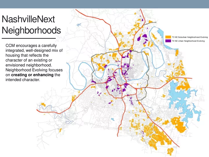

NashvilleNext Neighborhoods CCM encourages a carefully integrated, well-designed mix of housing that reflects the character of an existing or envisioned neighborhood. Neighborhood Evolving focuses on creating or enhancing the intended character.
Neighborhood Evolving Promote mixture of housing and greater connectivity Expressed interest in redevelopment High proportion of vacant or underdeveloped land No established lot pattern Discrepancies between land use and zoning Age/condition of existing development
Neighborhood Evolving Principles T3 Suburban Low to moderate density To create or enhance neighborhoods Moderate connectivity Moderate lot coverage Detached single-family and “ plex ” houses exist as predominant types Driveway access Parking lots in front Complete network of local, collector, and arterial streets provides residents with multiple routes T4 Urban Mix of housing types versus groupings of single types Moderate to high density Mix and placement of housing considers street type High connectivity High lot coverage Higher density adjacent to higher intensity policy Alley access Buildings at edge of policy area step down toward Parking lots at back lower density areas
“To create or enhance neighborhoods” Infill – Enhance the neighborhood Greenfield – Create the neighborhood Tracts of land without an existing framework Vacant or underdeveloped lots within an of infrastructure and development/lot pattern existing framework of infrastructure and development/lot pattern of a neighborhood
T3 Neighborhood Evolving - Greenfield Example 12452 Old Hickory Boulevard Request to rezone from AR2a to SP-R for 45 multi-family units
12452 Old Hickory SP Submittal
12452 Old Hickory Analysis of Context • Mix of rural and suburban development • AR2a, RS10, and SP • Adjacent properties T3 NE • Proximity to center and corridor policies • New development primarily conventional suburban • Approved subdivision to north • Auto-dominated with limited connectivity • Frontage on a collector • Proximity to schools • Proximity to transit • Absence of community parks • Limited services • Multiple planned streets
12452 Old Hickory Analysis of Proposal Design doesn’t create or contribute to a neighborhood. Absent of streets and blocks Disconnected open space Isolated site design Significantly different from emerging character
Priorities for Creating Neighborhoods Establish the base framework of streets and blocks Identify the neighborhood focal point(s) Plan the development and lot pattern for the neighborhood
Step 1: Establish the base framework • Highest priority is creating streets and blocks • Look beyond edges of property when making street connections, extensions, or stub outs • Streets are located strategically to establish a cohesive, complete, and connected network • Existing street pattern in the immediate area is applied or extended to the property • Street pattern works toward connecting existing streets within a half-mile radius • Streets create intersections and corridors appropriate for the planned range of housing types and intensities
Step 2: Identify the neighborhood focal point(s) • Locale natural features, such as steep slopes, high/low points, drainage patterns, etc • New developments that create a new street or internal drive system also create inviting, functional, and accessible open space beyond stormwater management • Open space protects, incorporates, or enhances conservation areas
Step 3: Plan development for neighborhood • Promote moderate density with smaller lots and diverse mix of housing types • Placement and intensity of housing creates the neighborhood form • Housing type, mix, placement: Responds to street type/limitations Designed to be cohesive throughout and to adjacent properties Avoids groups of single types • Housing types at top of the height and intensity range are located at the edge of the policy area, next to higher intensity policy areas (centers, corridors, districts) • Housing types at middle of height and intensity range are located at intersections of continuous streets
Staff’s Guidance • Sets up a street network • Identifies the focal point • Incorporates a mixture of housing types • Transitions to single- family detached lots
Incorporating Evolving Policy Guidance Final Proposal Initial Submittal
T4 Neighborhood Evolving - Infill Example 2122 Herman Street Request to rezone from RS5 to RM20
2122 Herman St Analysis of Context • Proximity to Tier One Centers and Transition Areas • Frontage on a collector • Established urban street and lot/block pattern • Primarily single-family detached; interspersed two-family • Institutional uses • High percentage of vacant lots • Alley access; Driveway access rare • Primarily zoned RS5; RM20 to east • Small, aging housing stock • Incomplete sidewalk network • High internal connectivity; low external connectivity • Proximity to schools and college • Proximity to transit
2122 Herman St Infill Guidance • “Infill sites may produce a different housing type to increase diversity and connectivity” • Different housing type could be appropriate along Herman St (Collector Avenue) • Attention to type, scale, massing, and transitioning to single-family homes north of alley • Development should incorporate elements of the existing developed character along Herman • Recommend SP
2122 Herman St Submitted SP
2122 Herman St Design Guidance • Placement of homes along Herman incorporates elements of existing character • Transitioning to single- family homes north of alley • Alley access • Attention to pedestrian circulation
Incorporating Evolving Policy Guidance Initial Submittal Final Proposal
Discussion
Recommend
More recommend