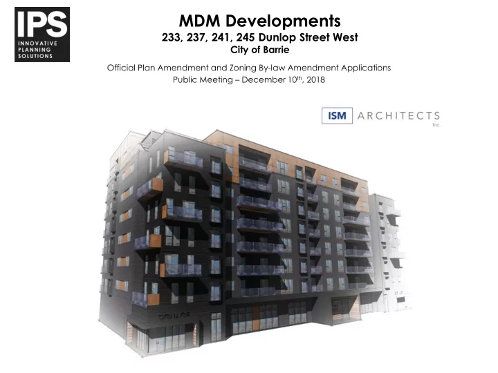

MDM Developments 233, 237, 241, 245 Dunlop Street West City of Barrie Official Plan Amendment and Zoning By-law Amendment Applications Public Meeting – December 10 th , 2018 Horseshoe Valley Subject lands
Application Context Site: • Frontage: 80.89 metres • Area: 0.52 ha • Currently one (1) single detached dwelling Surrounding Land Uses: • Low/ Medium Density Residential • Mixed Use and Commercial • Bunker’s Creek
Application Context
Official Plan Designation City of Barrie Official Plan Schedule A – Land Use Designation: Residential, Environmental Protection
Zoning City of Barrie Comprehensive Zoning By-law 2009-141 Zoning: RM2 (SP-189) (H-112)
Schedule I – Intensification Areas SUBJECT LANDS Located along a Primary Intensification Corridor, proximate to Primary Intensification Node
Development Proposal 8 Storey Apartment • Building 96 Rental units • Mixture of one and two • bedroom units, ranging from 559 - 1,076 ft² Two ground floor • commercial units ( 103 Parking spaces • Individual (Balconies) • Common Amenity Areas • (2 rooftop & 1 at grade)
Official Plan Amendment SUBJECT LANDS Subject site located within Special Policy Area [K] – Schedule C • Amendment to Special Policy Area to permit a maximum density • of 186 units/hectares on a site specific basis
Zoning By-law Amendment PROVISION MU2 REQUIREMENT PROVIDED Lot Area (min.) - 5,185.21 m 2 Lot Frontage (min.) - 80.89 m Setbacks Front Yard (min.) 1m for 75% of frontage 0.53 m Front Yard (max.) 5m for 25% of frontage Side Yard (min. abutting street or laneway) 3m 3.0 m Side Yard (max.) 3m Rear Yard (min. abutting street or laneway) 1.5m Rear Yard (min. abutting Res, OS, or EP) 7m 20.89 m Front Façade Step-back (min.) 45 degree angular plane at height above Compliant 80% equivalent of right-of-way using 3m minimum step-backs Rear Façade Step-back (min.) 45 degree angular plane above 7.5m Compliant using minimum 3m step-backs Lot Coverage (max. % of lot area) - 23.70% Gross Floor Area (max. % of lot area) - 171.70% Street Level Floor Height (min.) 4.5m 4.5 m Building Height (min.) 7.5m Building Height (max. with commercial use) 25.5m 25.85m Minimum Coverage for Commercial Uses 50% of GFA of street level floor area 60.4% Parking – Residential (min.) 96 (w/ 4 BF, 2 ‘A’ & 2 ‘B’) 96 (w/ 4 BF, 2 ‘A’ & 2 ‘B’) 7 (w/ 1 Type ‘A’ BF) Parking – Commercial (min.) 7 (w/ 1 Type ‘A’ BF) Landscaped Buffer for Parking Areas abutting a 3 m 1.3 m Residential Zone (min.) Landscape Buffer for Apartment Buildings (min.) 3 m 1.5 m
Architectural Rendering
Shadow Impact Study
Tree Preservation Plan Legend: Red (removed), Green (preserved), Yellow (being surveyed)
Planning Policy • Proposed development makes efficient use of existing infrastructure, is located along a primary intensification corridor, and proximate to a primary intensification node. • Offers a diversified housing stock through mixture of size and tenure. • Accessible and conducive to active and public transit. • Proposed application is in conformity with the goals and objectives of the Provincial Growth Plan, Provincial Policy Statement, and the City of Barrie Official Plan.
Conclusion • Official Plan Amendment and Zoning By-law Amendments are required to permit the proposed development. • OPA proposes to create a Special Policy for the subject lands to permit the proposed density. • ZBA proposes to rezone the lands to Mixed Use Corridor (MU2 SP-XXX) Zone. • Development provides appropriate, compact, and functional residential and community growth.
Questions & Comments
Recommend
More recommend