LA DURA PROJECT Au and Ag MUNICIPALITY TAMAZULA, DGO. The project - PowerPoint PPT Presentation
LA DURA PROJECT Au and Ag MUNICIPALITY TAMAZULA, DGO. The project is located approximately 275 km in straight line to N 55 W of the city of Durango, belongs politically to the municipality of Tamazula, and locally is located 2.3 km in
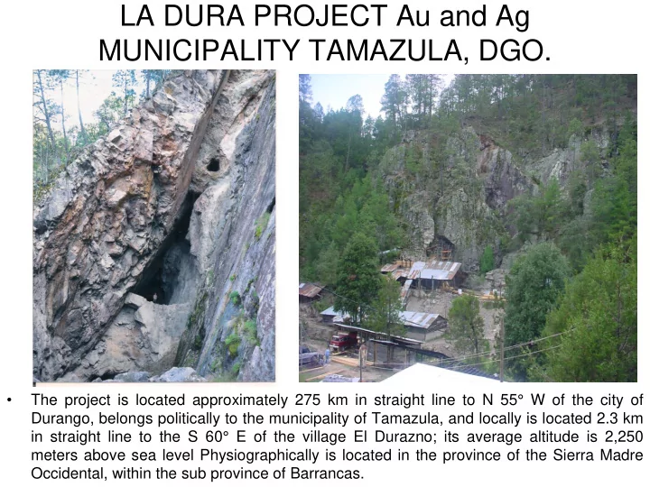
LA DURA PROJECT Au and Ag MUNICIPALITY TAMAZULA, DGO. • The project is located approximately 275 km in straight line to N 55° W of the city of Durango, belongs politically to the municipality of Tamazula, and locally is located 2.3 km in straight line to the S 60° E of the village El Durazno; its average altitude is 2,250 meters above sea level Physiographically is located in the province of the Sierra Madre Occidental, within the sub province of Barrancas.
CONCESSIONS • TITLE SURFACE • La Dura 51845 5 hec • Ampliación La Dura 196005 240 hec • La Dura Plus 220859 258 hec • La Dura Plus 220860 258 hec • La Dura 234913 1291 hec • -------------- • Total 2052 hectares • HOLDER Compañía Minera Copalquin, S.A. de C.V. • All lots are currently in force and up to date in the payment of taxes and all their obligations.
LOTS • P.P. is located at geographical coordinates 25 ° 29'30 "North latitude and 106 ° 54'30" West length relative to the Greenwich Meridian.
LOCATION AND ACCESS • From Parral, Chih., by paved road to El Ocote (235 km), from El Ocote by paved road to Las Banquetas (70 km), from Las Banquetas by dirt road (which already is being paving), to La Dura (35 km), the trip is done in 7 hours. • Route flights from Culiacan, Sin., to El Alizal from Monday to Saturday (30 minutes). • From Culiacan, Sin., 48 km paved and 135 km of dirt road to El Durazno, the trip is done in 6 hours.
RELEVANT DATA • The surface land is owned by the company. • Another attraction is the security in the area and not conflict with other owners or concessionaries of the Land (not ejidos). • Electric power is located 600 meters away from existing facilities (there are comments that CFE is about to cover this distance). • The terreros, of the ancient works of the mine that is believed began at the end of the 19th century and beginning of the 20th century until 1975 averaged grades of 4 g/t Au and 400 g/t Ag. • Ore shoots of very rich mineral have given grades of up to 135.4 g/t Au and 7,718 g/t Ag. • It has excellent access by land, either Parral Chihuahua or Culiacan Sinaloa. • The Stream San Ignacio, that passes on one side of the current installations of the flotation plant provides enough water for their operation (Ph 7). • The ore is floatable with recoveries of 85.7% Au and 73.71% Ag. There is no harmful content of antimony and arsenic.
HISTORIC DATA • The La Dura mine is a gold and silver mining operation that has been property prior to 1926 of the family De La Rocha, the mine has been worked intermittently since those years at low level. In 1926 the geologist A.R. Fletcher made a visit and consider it an important prospect. Until 1973 the CRM (1993) reports that 100,000 tons had been mined. • In 1975 there was a benefit plant for 20 tons/day and processed for 2 years all existing terreros from the ancient works of the La Dura mine, which had an average grade of 4 g/t Au and 400 g/t Ag; which gives us an idea of the grades that were benefited by the ancients in the numerous Taunas who were along the stream of San Ignacio. Around 1971 from La Chinaca ore shoot were extracted rich grades similar to the of Giovana, this material was extracted just crushed and sent by plane to Culiacan, Sin. • In 1979 was formed the CIA Minera La Dura, S.A. de C.V., the beneficiation plant is broad to 60 tons per day, which has worked it until June 2013 with a relatively constant production, with the exception of 1999-2009 which was stopped by low metals prices. • There is no complete information of the grades and the pass production of the mine, is estimated by the dimensions of the carvings, in at least some 300,000 tons of ore extracted of silver with gold values (from 1979 to date). • Grades have greatly fluctuated with periods of very low grade (1 g/t Au and 100 g/t Ag) with intermittent production of high-grade production with the best in the late 1997-early 1998 when sent around 100 tons of only crushed ore (Giovana ore shoot) with an average grade of 91 g/t Au and 4240 g/t Ag. (see table below, where sulphur material is only crushed material). Regularly it has been a production with average grades of 2 g/t Au and 200 g/t Ag. • The project has never been evaluated with modern exploration techniques including mapping, sampling of soils and surface or diamond drilling. Some underground exploration has recently been completed in the northwestern part of the main area of the mine trying to locate the vein of Plan 3-Minita at depth.
SMELTING SHIPMENTS 1996-1998
BENEFIT PLANT BY FLOTATION 60 T/D
GEOLOGY I.- Regional Geology.- It is made up of a sequence of Cenozoic volcanic rocks, • resting on a basal sedimentary section of Mesozoic age, which in turn are intruded by igneous bodies associated with the East border of the Batholitic complex of Sinaloa. • The volcanic rocks belong to the two large subdivisions established informally to the Sierra Madre Occidental by McDowell and Keiser (1977), which are the Lower Volcanic Complex and the Upper Volcanic Supergroup. • The upper volcanic complex is formed by felsic volcanic rocks, mainly by ignimbrites, tuffs, spills of rhyolitic composition. These rocks are found in most of the region forming the topographic highs and the thick folder of the Sierra Madre Occidental in the form of plateau, to this sequence is assigned an age of the Middle tertiary, ranging from 34 to 27 m.a. The igneous bodies ranging from granodiorites to quartz monzonites, tonalities, and diorites, the first being dominant, there is wide variation in the range of ages within the same region, but with a tendency to be more young to the East (Henry C.D., 1975). II.- Local Geology.- The geology that is in the area of study is represented by rhyolitic tuffs, which belongs to the upper volcanic series package, this being the encajonante rock of the existing mineralization; is located where the level of erosion is at a juvenile stage and acid volcanic rocks package is being eroded to discover even the pre-existing rocks such as the andesitic series, which in adjacent areas are recipients of economic mineralization. Megoscopicamente presents a light brown color to greenish with variations to reddish brown, with crystals of quartz and porphyritic texture. The microscope presents a pyroclastic texture; with quartz, feldspar, devitrified glass, sericite, chlorite, calcite, hematite, limonite, rock fragments, altered ferromagnesium and clay minerals.
• In this rock there is a pseudo stratification of strike NW 40° SE with inclination of 20° SW, between the fault 2 and the fault 3, thus also arise small dikes of andesitic composition which makes us think the lower sequence must be shallow, which is the principal recipient of the economic mineralization in adjacent areas. III.- GEOLOGY AND MINERALIZATION.- The La Dura mine is located in the upper • tertiary volcanic package, possibly at the bottom, since in addition to emerge rhyolitic tuffs casing structures, they were observed in the part SE spills andesitic and dykes of the same composition, the first in contact faults with the rhyolitic tuffs. Andesite occurs as irregular exhibitions in rocks highly faulted including minor rhyolite, suggesting that they were originally the dykes that have been interrupted due to faulty. • The mineralization is structurally controlled by a shear zone of strike NW38 ° to 55°SE and cast out of 56 ° to 76 ° NE, bounded by two very strong faults identified as fault 1 on bass and fault 3 of the high and one intermediate known as fault 2, finding economic mineralization auroargentiferous in the faults and the breccia with erratic grades. • There was development of tectonic origin breccia associated with especially the fault 3, although it was also observed between the faults, the fragments of the breccia are rhyolitic Tuff only and is very compact, partly cemented by Quartz. The fracturing of shear is more or less continuous and parallel about faults and more erratic in the intermediate rock between structures; This Rock is located in silicified parts and/or epidote. Failures are separated in surface about 40 meters, but at depth, vertical 138 meters, on the last level, the separation is 11 m, so it would be favorable to a greater concentration of economic mineral.
• Five distinct mineralized zones have been identified. By far, the dominant projection is main La Dura mine and zones mineralized northwesterly prolongation. The areas are described in the section mining works later. • IV.- Structures.- 3 parallel faults were identified, fault 1 striking NW 50 ° SE, 54 ° NE, the fault 2 striking NW 55 °SE, 65 ° NE and fault 3 of striking NW 35 °SE, 86 ° NE, as well as a fault of N-S direction with a dip of 86° E to vertical, which is truncating the faults 1, 2 and 3 in their SE portion, economic mineralization is located in the intense fracturing with breccias of quartz and silicified that occurs among these faults, as well as in the backrests of them. • Faults 1 and 2 come join in the intermediate level (2163 m) continuing to depth as a single structure which tends to join fault 3 at a depth of 150 m (2090 ft) approximately from the curb of manteo shot.
Recommend


More recommend
Explore More Topics
Stay informed with curated content and fresh updates.