Geo-Surveys and Security Applications of Infotron drone helicopter - PDF document
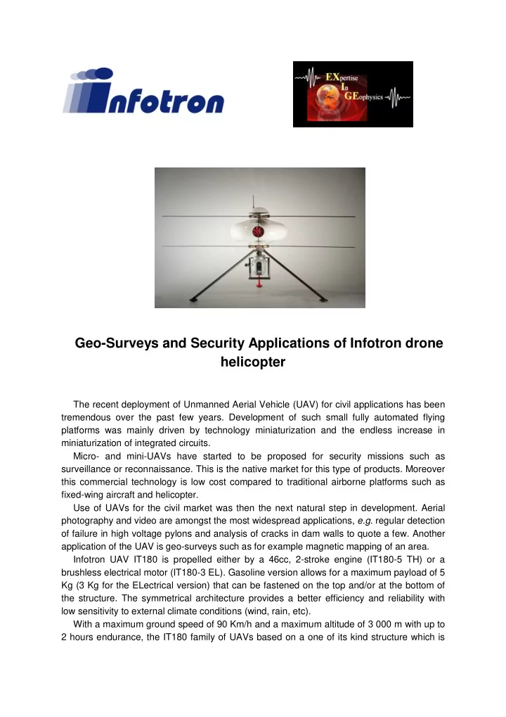
Geo-Surveys and Security Applications of Infotron drone helicopter The recent deployment of Unmanned Aerial Vehicle (UAV) for civil applications has been tremendous over the past few years. Development of such small fully automated flying
Geo-Surveys and Security Applications of Infotron drone helicopter The recent deployment of Unmanned Aerial Vehicle (UAV) for civil applications has been tremendous over the past few years. Development of such small fully automated flying platforms was mainly driven by technology miniaturization and the endless increase in miniaturization of integrated circuits. Micro- and mini-UAVs have started to be proposed for security missions such as surveillance or reconnaissance. This is the native market for this type of products. Moreover this commercial technology is low cost compared to traditional airborne platforms such as fixed-wing aircraft and helicopter. Use of UAVs for the civil market was then the next natural step in development. Aerial photography and video are amongst the most widespread applications, e.g. regular detection of failure in high voltage pylons and analysis of cracks in dam walls to quote a few. Another application of the UAV is geo-surveys such as for example magnetic mapping of an area. Infotron UAV IT180 is propelled either by a 46cc, 2-stroke engine (IT180-5 TH) or a brushless electrical motor (IT180-3 EL). Gasoline version allows for a maximum payload of 5 Kg (3 Kg for the ELectrical version) that can be fastened on the top and/or at the bottom of the structure. The symmetrical architecture provides a better efficiency and reliability with low sensitivity to external climate conditions (wind, rain, etc). With a maximum ground speed of 90 Km/h and a maximum altitude of 3 000 m with up to 2 hours endurance, the IT180 family of UAVs based on a one of its kind structure which is
fully patented (counter rotating double rotor, etc), is a de-facto market reference for performance in the mini UAV category. The presentation will describe the works and the result of various surveys performed to date by Infotron and its customers (some of which purchased a drone for their activities). Speaker biography Laurent Ameglio obtained a B.Sc. (Hons) in ‘Geophysics and Geology’ in 1991 and a M.Sc. in ‘Geophysics and Mineral Exploration’ in 1992, both from the University of Nancy (France). He obtained his Ph.D. in ‘Geophysics and Structural Geology’ from the Universities of Toulouse and Nancy (France) in 1997. During the course of his doctoral research Laurent also spent 14 months attending to his compulsories French military duties as reserve officer. Laurent started his career as junior lecturer during his Ph.D. and joined the Geology Department at Rhodes University (South Africa) as post-doctoral researcher in geophysics until 2000. He was a private geophysicist consultant in 2001 before joining the University of Pretoria (South Africa) as Senior Lecturer and Head of the Geophysics Division of the Geology Department for 2 years. Laurent then joined Fugro Airborne Surveys (Pty) Ltd. South Africa in 2003 as Senior Geophysicist, and was subsequently promoted Chief Geophysicist in 2004, Manager Airborne Projects in 2005 and Operations Manager in 2006. In 2007 Laurent created South African consulting and contracting company EXIGE (EXpertise In GEophysics) of which he is still the Managing Director. In 2008 he was also Vice-President of Canada based Terraquest Airborne Geophysics Ltd. In 2011 Laurent was also appointed CEO of GyroLAG (Gyrocopter Light Airborne Geophysics). Laurent also held honorary academic positions at Stellenbosch University (South Africa) and Monash University (Australia). Laurent has published well over 50 technical papers and has been the recipient of a few awards and fellowships for excellence in his work in geophysics. Companies profiles INFOTRON is a France based, privately owned company dedicated to the development and sales of Unmanned Aerial Vehicle (UAV) with Vertical Take Off and Landing capability (VTOL type). The UAV IT180 is propelled either by a 46cc, 2-stroke engine ( IT180-5 TH ) or a brushless electrical motor ( IT180-3 EL ). Gasoline version allows for a maximum payload of 5 Kg ( 3 Kg for the Electrical version) that can be fastened on the top and/or at the bottom of the structure. The symmetrical architecture provides a better efficiency and reliability with low sensitivity to external climate conditions (wind, rain...). With a maximum ground speed of 90 Km/h and a maximum altitude of 3 000 m with up to 2 hours endurance, the IT180 family of UAVs based on a one of its kind structure which is fully patented, is a de-facto market reference for performance in the mini UAV category. INFOTRON IT180 UAV family achieves a high security level by integrating multiple sensors managed with an embedded software communicating with the base station via a secure triple radio link. The semi automatic pilot mode allows the operator to focus on the usage of the gyro-stabilized camera (day sensor, night sensor or day & night sensors) to observe the
area of interest. Power and stability of the camera (zoom x26 ) will send back (over a distance of 10 Km ) on all potential dangers. Contact person - Mr. Francis Durufle (INFOTRON - Sales & Marketing Director) Cell.: +33 6 35 47 61 93 Email: fdurufle@infotron.fr Web: www.infotron.fr EXIGE ( EX pertise I n GE ophysics), is a geophysical consulting and contracting company established in 2007 in Johannesburg (South Africa). Revolving around its G 4 - Geophysics, Geology, Geochemistry & Geo-systems global strategy, EXIGE offers turnkey geophysical solutions in airborne , ground , marine and wireline applications to the natural resources exploration, environmental, civil engineering and precision agriculture industries. Out of the box thinking and deployment of innovative and leading edge technologies such as e.g. the unique GyroLAG ( Gyro copter L ight A irborne G eophysics) or WASP ( W ingless A utonomous S urvey P robe - partnership with Infotron) are a key to EXIGE making a difference. Development and activities of EXIGE and its associates and partners (Airwatch, Wireline Workshop, Open Ground Resources, Global Geophysical, Infotron, Land & Marine Surveys) are available at www.exigesa.com and also regularly showcased in EXIGE’s quarterly bulletin (digital edition) Geophysics PathFinder . Contact person - Dr. Laurent Ameglio (Managing Director) Tel./Fax: +27 12 259 0651 Cell.: +27 84 787 1000 Email: laurent@exigesa.com Web: www.exigesa.com
Recommend


More recommend
Explore More Topics
Stay informed with curated content and fresh updates.